|
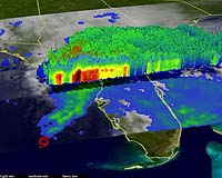
Greenbelt MD (SPX) Dec 10, 2007 Researchers have found that when residents of the U.S. southeastern states look skyward for rain to alleviate a long-term drought, they should be hoping for a tropical storm over a hurricane for more reasons than one. According to a new study using NASA satellite data, smaller tropical storms do more to alleviate droughts than hurricanes do over the course of a season by bringing greater cumulative rainfall. A new study that provides insight into what kind of storms are best at tackling drought in the southeastern United States. The study focuses on a decade of first-ever daily rainfall measurements by a NASA satellite carrying a weather radar in space. The study's authors believe the same insights can be applied by meteorologists and public officials to other regions where daily satellite rainfall data and storm tracking data are available. In the wake of Hurricane Katrina, meteorologist Marshall Shepherd, an associate professor of geography and atmospheric sciences at the University of Georgia, Athens, and colleagues delved into the ongoing debate about whether global warming is leading to an increase in rainfall intensity. The researchers wanted to determine how much rainfall each type of cyclone, from tropical depressions to category five hurricanes, contributes to overall rainfall. They focused the study on the Southeast in the hope that results could be harnessed to improve drought relief information for the region. Their findings were published today in the American Geophysical Union's Geophysical Research Letters. "As much of the Southeast experiences record drought, our findings indicate that weak tropical systems could significantly contribute to rainfall totals that can bring relief to the region," said Shepherd, lead author of the NASA-funded study. "These types of storms are significant rain producers. The larger hurricanes aren't frequent enough to produce most of the actual rain during the season and therefore are not the primary storm type that relieves drought in the region." Shepherd created a new measurement method as an efficient way to get a real sense for how much rainfall each type of storm contributes in a given year around the coastal regions of the southeastern U.S. To do so, he had to distinguish an average rainfall day from an extreme rainfall day. Though data from NASA's Tropical Rainfall Measuring Mission (TRMM) satellite could offer daily rainfall amounts, the data could not be used to set apart whether rainfall was average or extreme for any given day. Shepherd and his team modeled their metric on the "cooling degree day" that energy companies use to relate daily temperature to energy needs for air conditioning. A cooling degree day is found by subtracting 65 degrees from the average daily temperature. Values larger than zero give some indication whether a day was abnormally warm. Shepherd used daily rainfall data from TRMM to determine 28.9 as the base value of average daily rainfall at one of the world's wettest locations, Maui's Mount Wailea in Hawaii. In the same way as the cooling degree day, the "millimeter day" metric is calculated by subtracting 28.9 millimeters from the average daily rainfall in each of four ocean basins along coastal areas scattered across the south near Houston and New Orleans, east of Miami and south of North Carolina. Values greater than zero indicate a so-called "wet millimeter day" of extreme rainfall. Using daily rainfall data from the TRMM satellite from 1998-2006, Shepherd's team compared the amount of rain that fell in the basins on extreme rainfall days with the location of tropical storms from the National Hurricane Center's storm tracking database to determine how many extreme rainfall days were associated with a particular type of tropical storm. The team found that the most extreme rainfall days occurred in September and October, two of the busiest months of the Atlantic hurricane season. They also found that though major hurricanes produced the heaviest rainfall on any given day, the smaller tropical storms and depressions collectively produced the most rainfall over the entire season. Over half of the rainfall during the hurricane season attributed to cyclones of any type came from weaker tropical depressions and storms, compared to 27 percent from category 3-5 hurricanes. TRMM has transformed the way researchers like Shepherd measure rainfall by providing day-to-day information that did not exist before the satellite's 1997 launch. "Though we've had monthly rainfall data available since 1979 from other sources, it's the daily rainfall data that allows us to see that tropical storm days contributed most significantly to cumulative rainfall for the season due to how frequently that kind of storm occurs," said Shepherd. "It's important in the future to build a longer record of daily rainfall to establish, with better confidence, whether trends are occurring," said Shepherd. "This study sets the stage for us to understand how much rainfall weak and strong tropical cyclones contribute annually and whether this contribution is trending upward in response to global warming-fueled growth in tropical cyclones." Shepherd believes advances that will improve study of cyclones and rainfall are "just around the corner" with NASA's Global Precipitation Measurement satellite, scheduled for launch in 2013. An extension of TRMM's capabilities, it will measure precipitation at higher latitudes, the actual size of snow and rain particles, and distinguish between rain and snow. Community Email This Article Comment On This Article Related Links NASA's Hurricane Resource Page Tropical Rainfall Measuring Mission project site Bringing Order To A World Of Disasters When the Earth Quakes A world of storm and tempest
 Miami (AFP) Dec 7, 2007
Next year's Atlantic hurricane activity should be slightly higher than average, forecasters said Thursday, following a cyclonic season that was quieter than anticipated but caused devastation in central America. |
|
| The content herein, unless otherwise known to be public domain, are Copyright 1995-2007 - SpaceDaily.AFP and UPI Wire Stories are copyright Agence France-Presse and United Press International. ESA Portal Reports are copyright European Space Agency. All NASA sourced material is public domain. Additional copyrights may apply in whole or part to other bona fide parties. Advertising does not imply endorsement,agreement or approval of any opinions, statements or information provided by SpaceDaily on any Web page published or hosted by SpaceDaily. Privacy Statement |