|
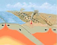
Berkeley CA (SPX) Jan 26, 2005 Some massive earthquakes like the one that generated the recent tsunami in South Asia are preceded by slight sinking along nearby coastlines two to five years before the rupture, according to a new study by scientists from Dalhousie University in Nova Scotia, the University of California, Berkeley, and the Alaska Division of Geological and Geophysical Surveys. If coastal subsidence is common before subduction zone quakes, areas such as those ringing the Pacific Rim could be on the lookout for subsidence as a warning of possible future megathrust quakes like the Dec. 26 9.0 Sumatra-Andaman Islands earthquake, the researchers say. "In areas along subduction zones, like the Northwest coast of the United States, we should look to see where the land has subsided and put instruments there to monitor it," said Jere Lipps, a UC Berkeley professor of integrative biology and study coauthor. "If the land continues to subside instead of relaxing back to normal, it could indicate a big earthquake and a tsunami might occur some time in the next few years." Subduction zones are areas where one of the Earth's tectonic plates slips under another, raising mountain ranges along the margin sprinkled with volcanoes. Quakes occur when the edge of the overlying plate sticks to the subducting plate, causing a slight dip nearest the zone and a slight bulge farther away. Eventually, the stuck edge lets go in a massive quake, after which the margin relaxes to pre-quake levels. Because plates thrust over one another in these zones, the quakes are referred to as megathrust earthquakes. They often generate tsunamis. "What we think happens is, two to five years before a quake, the plate boundary starts to drag down ever so slightly before it fractures," said David B. Scott, the Killam Professor of Earth Sciences at Dalhousie University in Halifax." Before that, you've got subsidence that is almost undetectable to the people living there. But you could detect it with a tiltmeter. We have shown that we can detect it in the paleoenvironment." The study was conducted by Scott and Lipps, both micropaleontologists, along with Dalhousie undergraduate Andrea D. Hawkes and Rod Combellick of the Alaska Division of Geological and Geophysical Surveys in Fairbanks. A paper describing their findings will be published in the May/June issue of the Geological Society of America Bulletin. The team surveyed salt marshes along the Pacific coast from Alaska to northern California, taking 12-foot deep cores to look for signs of past subsidence coinciding with evidence of a major quake, such as soil liquefaction and sand deposited by a tsunami. Subsidence is indicated by a temporary change in the types of microscopic organisms with shells � specifically foraminifera and thecamoebians � in the mud, as the formerly freshwater marshes sink and become brackish or saltwater marshes. One marsh in Alaska apparently sank about half a foot starting perhaps 15 years before the devastating 1964 Alaska quake, which measured 9.2 on the Richter scale and generated a tsunami that killed dozens of people along the Pacific coast. Similarly, a core from a marsh in Oregon showed evidence of four large quakes over the past 3,000 years, each preceded by subsidence. Seismologists estimate that the period between megathrust quakes along the Cascadia Subduction Zone, where the Pacific, Juan de Fuca and Gorda Oceanic plates creep under the North American plate, ranges from hundreds to thousands of years. This makes them hard to plan for, Scott noted. Precursory subsidence detected by tiltmeters would at least allow people along the coast to plan for a major quake and probable tsunami. The indicator marshes are typically fresh water marshes within inches of the high tide mark, so that subsidence of a few inches increases slightly the saltiness of the march, either through salt spray or intrusion of salt water at high tide, and shifts the species of foraminifera living there. Marshes like those sampled in this study would be ideal sites for installation of tiltmeters, the researchers said, because of their past history of earthquake precursors. In the past, Scott has looked in sediments for foraminifera and thecamoebians � essentially amoebas with microscopic shells � deposited by past hurricanes along the Atlantic coast and into the Arctic. He was intrigued, however, by the efforts of other researchers to use diatoms or pollen to chart the history of quake-related subsidence in marshes along the Pacific coast. The big 1964 Alaskan quake, for example, temporarily dropped some coastal land six feet, drowning towns and forests, the latter becoming standing "ghost forests." Scott thought that forams and thecamoebians might be able to give more precise dates for precursory subsidence, since they are more sensitive than diatoms to elevation changes. Thecamoebians, for example, live only in fresh water. Looking initially at a core from Girdwood Flat, a marsh at Turnagain Arm in Cook Inlet, the site of the 1964 Alaska quake, he spotted an obvious precursor event just prior to that quake. "About a centimeter below the quake itself, I saw this phenomenal change in the fauna, going from a bunch of species that live in the forest to a slightly brackish fauna with only one species," he said. Teaming up with Lipps, Scott said, "we started looking at other sequences to make sure that wasn't just a one-off thing. It turned out we were able to see an 1,800-year event from the same area and, of course, we went down to Oregon and found the same thing." Four of the cores from Girdwood Flat showed evidence of subsidence as much as 15 years before the 1964 quake, and one core contained evidence of a quake with precursory subsidence 1,800 years ago. The subsidence is distinct from the much larger drop that occurs during the quake itself. In a core from Netarts Bay, Oregon, just north of Tillamook, the species of foraminfera present indicated three repeating sequences of high marsh transitioning to low marsh as the land began to sink, then tsunami sand without foraminifera, followed by a return to high marsh as the land relaxed after the earthquake. (Sand deposited by tsunamis can be distinguished from storm-deposited sand because the former scours the deep bottom where there are few forams, while storms carry sand from shallow waters that contain many forams.) The three sequences corresponded to megathrust quakes and tsunamis 3,000 years ago, 1,840 years ago and 1,670 years ago, though the core revealed a fourth event 300 years ago not accompanied by a tsunami but showing precursory subsidence as well as sudden subsidence due to a quake. Stems, twigs and driftwood embedded in the sand and mud were used to carbon-date the core sections. Independent evidence of these past quakes exists only for the 300-year-old event. Scott noted that more than a dozen estuaries between Clayoquot Sound, British Columbia and the Eel River in California record evidence of buried marsh or forest soils, and may be good sites for future monitoring. Whether suitable coastal marshes can be found near all subduction zones is a big question, however, and not all subduction zones may act the same. "It could be that subduction zones don't look the same everywhere � there may not be subsidence before a quake," said Lipps, whose main interest is the evolution of forams and other ancient life forms. Lipps and Scott have sampled similar situations around the Pacific Rim and found evidence of quakes and tsunamis in cores from New Zealand, Mexico and Tahiti. They plan to do the same in the Indian Ocean to look for evidence of precursors to megathrust quakes and to document the history of tsunamis there. They also will attempt to pinpoint more precisely the time between land subsidence and earthquakes along the Pacific Northwest coast. Community Email This Article Comment On This Article Related Links Alaska Division of Geological and Geophysical Surveys University of California - Berkeley SpaceDaily Search SpaceDaily Subscribe To SpaceDaily Express Tectonic Science and News
 Sydney (AFP) Dec 12, 2005
Thousands of tonnes of ash are continuing to spew from a volcano in Vanuatu, but officials said Monday the activity on the South Pacific nation was not likely to result in a major deadly eruption. |
|
| The content herein, unless otherwise known to be public domain, are Copyright 1995-2006 - SpaceDaily.AFP and UPI Wire Stories are copyright Agence France-Presse and United Press International. ESA PortalReports are copyright European Space Agency. All NASA sourced material is public domain. Additionalcopyrights may apply in whole or part to other bona fide parties. Advertising does not imply endorsement,agreement or approval of any opinions, statements or information provided by SpaceDaily on any Web page published or hosted by SpaceDaily. Privacy Statement |