|
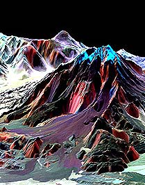
Washington - February 14, 2000 - The current shuttle mission will gather information key to the University of Hawai'i's research on the aftermath of volcanic eruptions. In November 1999, Professor Peter Mouginis-Mark, Hawaii Institute of Geophysics and Planetology, led a team of researchers in collecting information on the effects of the devastating 1991 Mount Pinatubo eruption in the Philippines. NASA's Shuttle Radar Topography Mission (SRTM) will provide more extensive topographic data on that specific area as well as most of the rest of the Earth. SRTM will employ an advanced measurement technique called "radar interferometry" to obtain topographic maps of the Earth's surface for use by scientists, emergency relief planners, commercial companies and many other investigators, according to NASA. One of the two radar antennae that will form this "interferometer" will be located on a 197-foot mast that will be the largest fixed structure ever flown in space. "It's providing a first look at the Earth's topography at this scale," Mouginis-Mark said. "Whether you're studying volcanoes, glaciers or mountains, the whole experience will be a tremendous one for all Earth scientists, which is why it's so exciting. And it's great that UH is once again involved in a space shuttle experiment." Mouginis-Mark has worked with NASA on volcano research for more than 16 years, including three other space shuttle experiments. UH presently uses related data from active NASA satellite Landsat 7, launched in April 1999, and expects to obtain information from the satellite Terra, which was launched last month. The scheduled launch for the 11-day SRTM aboard space shuttle Endeavour is Jan. 31, 7:47 a.m. HST. SRTM data collected for Pinatubo and other volcanoes will supplement UH's research into using satellites to monitor active volcanoes and the hazards they present. Mouginis-Mark said one aspect of this research is concerned with the way the topography of parts of the volcano is changing over time due to erosion of the 1991 ash by heavy rainfall. "We're trying to understand what the hazards are to people living around the volcano," he said. "The ash deposits that erode away are eventually re-deposited on the lower slopes in the form of dangerous mud flows, otherwise called 'lahars,' after it rains." Mouginis-Mark said the purpose of this research is hazard mitigation, which minimizes the dangers and devastation these lahars can cause. The project is significant to the state of Hawai'i, which is home to Kilauea, the Big Island's active volcano. The SRTM will use Kilauea as a calibration target, and the volume of its recent lava flows will be calculated using SRTM data.
Email This Article Comment On This Article Related Links Space
 Calcutta, India (SPX) Dec 28, 2005
The successful launch Thursday of India's heaviest satellite from spaceport of Kourou in French Guyana may have boosted the country's space research efforts to yet another level, but it has also lifted the spirits of at least three Direct-To-Home televisions broadcasters, one of which has been waiting for years to launch its services in India. |
|
|
|
|
|
|
|
|
|
|
|
|
|
| The content herein, unless otherwise known to be public domain, are Copyright 1995-2006 - SpaceDaily.AFP and UPI Wire Stories are copyright Agence France-Presse and United Press International. ESA PortalReports are copyright European Space Agency. All NASA sourced material is public domain. Additionalcopyrights may apply in whole or part to other bona fide parties. Advertising does not imply endorsement,agreement or approval of any opinions, statements or information provided by SpaceDaily on any Web page published or hosted by SpaceDaily. Privacy Statement |