|
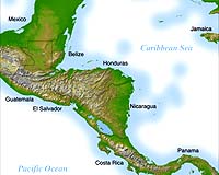
Pasadena - Oct 28, 2002 Underscoring how space technology can help us to better understand and protect our home planet, NASA's Jet Propulsion Laboratory, Pasadena, Calif., has completed the first comprehensive high-resolution topographic map of Central America, a region where persistent cloud cover had made high-quality satellite imagery difficult to obtain. A mosaic image created from the map depicts all of Central America�Belize, Costa Rica, El Salvador, Guatemala, Honduras, Nicaragua and Panama�plus southern Mexico and portions of Cuba and Jamaica. Home to 37 million people, Central America comprises just one-half percent of Earth's land mass, yet houses seven percent of Earth's animal species. The dominant topographic feature of northern Central America is the Sierra Madre Range, spreading east from Mexico between the narrow Pacific coastal plain and the limestone lowland of the Yucatan Peninsula. Parallel hill ranges sweep across Honduras and extend south, past the Caribbean Mosquito Coast to lakes Managua and Nicaragua. The Cordillera Central Mountains rise to the south, gradually descending to Lake Gatun and the Isthmus of Panama. A highly active volcanic belt runs along the Pacific seaboard from Mexico to Costa Rica. "Central America is a unique geographic region dominated by rugged mountains, heavy vegetation and influenced by two major oceans," said Dr. Michael Kobrick, Shuttle Radar Topography Mission project scientist at JPL. "Its proximity to Earth's equator and the Pacific and Caribbean results in frequent cloud cover, which makes traditional satellite imagery difficult. The Shuttle Radar Topography Mission's synthetic aperture imaging radar was able to penetrate that cloud cover, allowing the region to be mapped more precisely than ever before. "Residents of Central America stand to benefit greatly from this more precise digital elevation data, which can help them better prepare for natural hazards such as landslides and floods, improve aviation safety through a better understanding of mountainous terrain, and increase the efficiency of critical infrastructure developments such as roads, reservoirs, aqueducts and communications." Two visualization methods were combined to produce the image: shading and color coding of topographic height. The shade image was derived by computing topographic slope in the north- south direction. Color-coding is directly related to topographic height, with green at the lower elevations, rising through yellow, red and magenta, to white at the highest elevations. NASA is processing mission data for research purposes in response to requests from NASA principal investigators and other qualified scientists. NASA expects to release the Central America data for broad public access in 2003. The Shuttle Radar Topography Mission, flown from Feb. 11 to Feb. 22, 2000, made 3-D measurements of the more than 80 percent of Earth's landmass between 60 degrees north and 56 degrees south of the equator, areas home to nearly 95 percent of the world's population. The mission is a cooperative project of NASA, the National Imagery and Mapping Agency of the U.S. Department of Defense, and the German and Italian space agencies. Community Email This Article Comment On This Article Related Links Shuttle Radar Topography Mission SpaceDaily Search SpaceDaily Subscribe To SpaceDaily Express Earth Observation News - Suppiliers, Technology and Application
The National Geospatial-Intelligence Agency (NGA) Friday awarded a $24-million satellite imagery contract extension to Space Imaging. This ClearView contract option enables the NGA to acquire additional commercial imagery from Space Imaging's IKONOS satellite for another year. |
|
| The content herein, unless otherwise known to be public domain, are Copyright 1995-2006 - SpaceDaily.AFP and UPI Wire Stories are copyright Agence France-Presse and United Press International. ESA PortalReports are copyright European Space Agency. All NASA sourced material is public domain. Additionalcopyrights may apply in whole or part to other bona fide parties. Advertising does not imply endorsement,agreement or approval of any opinions, statements or information provided by SpaceDaily on any Web page published or hosted by SpaceDaily. Privacy Statement |