|
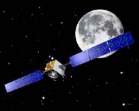
Paris (ESA) Nov 13, 2002 To get around, satellites sailing through space use the same tools that ancient mariners used to navigate the inhospitable oceans -- the stars. However, soon, instead of sending back details of their position to experts here on Earth, spacecraft will be able to calculate and adjust their course all by themselves. ESA now has special software that it will test on its SMART-1 mission, due for launch in Spring 2003. The first sailors used stars as reference points to find out where they were going. Generally, satellites use a 'star tracker' instrument that allows them to maintain their orientation in space using groups of stars as a reference point. The spacecraft's location in space is calculated using radio signals transmitted between the spacecraft and Earth. Experts process all these data here on the ground. Once that is done, they work out what adjustments are needed to the satellite's course for it to reach its proper destination. However, all of this is set to change following the introduction of new technologies during the SMART-1 satellite mission. There is a more 'intelligent' system that allows the spacecraft to determine its orientation autonomously. The data obtained by a new generation of star trackers, called 'star mappers', are processed and then compared with a map of the sky directly on-board the spacecraft. However, the real revolution in spacecraft navigation is OBAN, a new technology due to be tested on SMART-1. It will allow the spacecraft to determine autonomously its precise location in space, without being tracked by ground stations. This is the most important step towards a new generation of self-controlled spacecraft. "Only once a spacecraft is able to know exactly its position in space will it be able to decide by itself the best trajectory to follow to reach a defined target. That target maybe a planet or other celestial body, for example." says Andrea Marini, the engineer in charge of the experiment. "Spacecraft will 'understand' where they are located. They will be able to decide how to get to their target and monitor their own course all the time. This allows us to save precious fuel. It also allows the spacecraft to correct its path almost continuously. And the need for intervention from the ground is reduced, with all the associated costs." It took scientists more than 10 years to develop OBAN. During the mission they will run the OBAN software on Earth, combining and processing the data coming from the satellite's star mapper and AMIE. AMIE is a special camera that takes images of near-by asteroids and planets. In the future the OBAN package will be installed on-board spacecraft. However, SMART-1 will use traditional navigation methods alongside OBAN, allowing ground teams to test the accuracy of OBAN against their own calculations. Once the experiment is successfully completed, OBAN may well allow spacecraft travelling all over the Solar System to set their own courses. If they had only lived to see it, the navigators on-board the old ships that once sailed the Seven Seas on Earth would probably approve of this independence. Community Email This Article Comment On This Article Related Links More about SMART-1 More about OBAN SpaceDaily Search SpaceDaily Subscribe To SpaceDaily Express Space Technology News - Applications and Research
 Baltimore MD (SPX) Jan 12, 2006
A team comprised of three leading US aerospace and defense contractors has demonstrated an innovative technological use of active electronically scanned array (AESA) radars for high-bandwidth communications. |
|
| The content herein, unless otherwise known to be public domain, are Copyright 1995-2006 - SpaceDaily.AFP and UPI Wire Stories are copyright Agence France-Presse and United Press International. ESA PortalReports are copyright European Space Agency. All NASA sourced material is public domain. Additionalcopyrights may apply in whole or part to other bona fide parties. Advertising does not imply endorsement,agreement or approval of any opinions, statements or information provided by SpaceDaily on any Web page published or hosted by SpaceDaily. Privacy Statement |