|
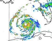
Boulder CO (SPX) Sep 22, 2005 An advanced research weather model run by the National Center for Atmospheric Research (NCAR) is following Hurricane Rita to give scientists a taste of how well forecast models of the future may predict hurricane track, intensity, and important rain and wind features. With its high-resolution grid of data points just four kilometers (about 2.5 miles) apart, the model can project the location of fine-scale rain bands and eyewall structures 48 hours into the future. It's these storm features that determine where the greatest damage from both rain and wind might occur, says NCAR weather expert Chris Davis. Current operational forecast models use a coarser resolution and must approximate the cloud processes affecting intensity and precipitation. Known as ARW, the computer model is NCAR's research version of the Weather Research and Forecasting model (WRF), a joint effort by university and government scientists. "ARW intensity predictions are very encouraging," says Davis. "Five years ago, accurate intensity predictions weren't even possible." The model captured in detail the collapse of Hurricane Katrina's eyewall at landfall and the shift of precipitation to the north side of the storm. Had the eyewall's structure remained coherent, the winds would have been far more devastating. However, an eyewall always weakens at landfall, says Davis. Teams supporting the Department of Energy and Department of Homeland Security are using real-time ARW data in their damage models. The researchers are testing how computer simulations of a particular hurricane's most destructive features might improve damage model projections and lead to better warnings of floods, power outages, and road blockage. This year's test cases have included hurricanes Katrina, Ophelia, and now Rita. Meanwhile, a hurricane experiment in Florida is investigating the interactions between Hurricane Rita's rain bands and its eyewall. NCAR's Wen-Chau Lee is flying through the storm aboard a Naval Research Laboratory P-3 aircraft to gather radar data from inside the bands. The observations from the Hurricane Rainband and Intensity Change Experiment (RAINEX) will help scientists better understand the impact of the rain bands on the storm's maximum winds. Community Email This Article Comment On This Article Related Links National Center for Atmospheric Research SpaceDaily Search SpaceDaily Subscribe To SpaceDaily Express Bringing Order To A World Of Disasters When the Earth Quakes A world of storm and tempest
 New Orleans, Louisiana (AFP) Jan 05, 2006
Thousands of students and faculty are returning to New Orleans' eight colleges and universities this week for the first time since hurricane Katrina flooded the city four months ago. |
|
| The content herein, unless otherwise known to be public domain, are Copyright 1995-2006 - SpaceDaily.AFP and UPI Wire Stories are copyright Agence France-Presse and United Press International. ESA PortalReports are copyright European Space Agency. All NASA sourced material is public domain. Additionalcopyrights may apply in whole or part to other bona fide parties. Advertising does not imply endorsement,agreement or approval of any opinions, statements or information provided by SpaceDaily on any Web page published or hosted by SpaceDaily. Privacy Statement |