|
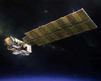
Greenbelt MD (SPX) Feb 09, 2005 Were you ever told you needed to step back and see the whole picture? Looking at Earth from space provides a perspective only dreamed about until the dawn of the Space Age. From that lofty viewpoint, an almost inconceivable amount of information flows from satellites that provide insight to better understand our planet. The largest scientific data system in the world - the Earth Observing System Data and Information System (EOSDIS) - collects environmental measurements from more than 30 satellites, such as NASA's Terra, Aqua, Aura and ICESat. The volume of data about our environment collected by these constant observers is truly amazing. To get some perspective, think of the largest library in the world: the Library of Congress in Washington, D.C. Its collection consists of nearly 128 million items on approximately 530 miles of bookshelves. This massive library contains 29 million books and other printed materials, 2.7 million recordings, 12 million photographs, 4.8 million maps and 57 million manuscripts. As massive as that sounds, the scientific data from EOSDIS could fill the Library of Congress 300 times. In other terms, it is the equivalent of a DVD movie with a running time of more than 160 years - with what would amount to 66 additional days of running time being added daily. Each day, these satellites produce images of the entire surface of the Earth and three-dimensional information reaching from the base of our atmosphere up beyond the stratosphere. From their perspective, they are able to capture amazing geological events and build a database that allows scientists to map the changes in our planet's environment. But just how is all this information used? The system provides unprecedented access to a diverse, worldwide group of more than 17,000 users. They consist of researchers, federal, state and local governments, teachers, museums, the commercial remote-sensing community and the general public. Daily, these users draw on this information at an astounding rate (using the DVD movie example, it would equal 1,056 hours of running time). The availability and access to this information is leading to unprecedented studies of land, ice cover, oceans and atmosphere, according to Dr. Carl. A. Reber, EODIS project scientist. "The EOSDIS has been a boon to the Earth-science research community," he said. While a 160-year-long movie would never be a top-selling DVD, the revealing perspective provided by our friendly observers in the sky will continue to help us see the "big picture" of planet Earth. Community Email This Article Comment On This Article Related Links SpaceDaily Search SpaceDaily Subscribe To SpaceDaily Express Earth Observation News - Suppiliers, Technology and Application
 New York NY (SPX) Jan 11, 2006
The importance of remotely sensed data and technologies to support natural disasters has prompted attention and action in Washington. New initiatives and legislation authorizing appropriations to the remote sensing industry will be discussed at Strategic Research Institute's U.S. Commercial Remote Sensing Industry conference, scheduled for February 9-10, 2006 in Washington D.C. |
|
| The content herein, unless otherwise known to be public domain, are Copyright 1995-2006 - SpaceDaily.AFP and UPI Wire Stories are copyright Agence France-Presse and United Press International. ESA PortalReports are copyright European Space Agency. All NASA sourced material is public domain. Additionalcopyrights may apply in whole or part to other bona fide parties. Advertising does not imply endorsement,agreement or approval of any opinions, statements or information provided by SpaceDaily on any Web page published or hosted by SpaceDaily. Privacy Statement |