|
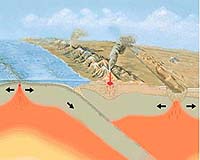
Seattle WA (SPX) Jan 31, 2006 The most powerful earthquakes � such as those that shook Indonesia in 2004, Alaska in 1964, Chile in 1960 and the Pacific Northwest in 1700 � occur in subduction zones, areas of the sea floor just offshore where two tectonic plates meet and one dives beneath the other. But not all subduction zones are created equal, and University of Washington researchers believe they have found a key to determine which subduction zones � or which specific areas within a subduction zone � might produce the most severe shaking when they rupture. As the subducting plate slides beneath the upper plate, stress begins to build where the plates meet and the upper plate can deform to create a large structure called a forearc basin. The basin, a sort of a bowl-shaped depression, fills with sediment from nearby rivers that empty into the ocean. Over millions of years, the sediment typically piles to great depths, from a half-mile to nearly 2 miles, and in rare cases might reach 3 miles deep, said Christopher Fuller, a University of Washington doctoral student in Earth and space sciences. "In many of them, the sediment will stop the deformation of the upper plate," Fuller said. "The simplest way to think of it is that the increased weight of the sediment stops the deformation from occurring." It appears the most severe subduction zone earthquakes occur in areas where such sediment-filled basins are found, but the reasons aren't exactly clear. Fuller and his colleagues conducted computer simulations of force experienced during plate subduction to determine how sediment buildup influences major earthquakes. They found that the weight of the sediment strengthens the edge of the plate directly above where the earthquakes happen. The stronger edge is deformed far less by subduction than nearby areas without such basins, he said, and that increases the likelihood that large earthquakes will occur in regions with basins. Fuller is the lead author of a paper explaining the modeling research, published in the February edition of the journal Geology. Co-authors are Sean Willett, a UW associate professor of Earth and space sciences, and Mark Brandon, a professor of geology and geophysics at Yale University. The work was supported by grants from the National Science Foundation. The Cascadia subduction zone off the coasts of Washington, Oregon and northern California has forearc basins in several areas, Fuller said. As it moves to the east at 2 inches a year, the Juan de Fuca tectonic plate slides beneath the North American plate that contains the landmass of the Pacific Northwest. In the process, sediment as deep as 1� miles is scraped off the top of the Juan de Fuca plate and is deformed into surface depressions on the North American plate, forming the basins where sediment from coastal rivers is deposited. The probability of large earthquakes is greatest in these areas. The modeling could have implications in figuring out where, within a subduction zone such as Cascadia, great earthquakes are the most likely to occur, Fuller said. But the work is not applicable to every subduction zone because each has different characteristics. For instance, forearc basins do not play the same role in the subduction zone off the Indonesian island of Sumatra, where the massive 2004 earthquake triggered tsunamis that killed hundreds of thousands of people. "You have to understand the nature of basins and how they work in each area before you can use them as an interpretive tool," Fuller said. "You can't just apply these correlations everywhere." Community Email This Article Comment On This Article Related Links University of Washington Bringing Order To A World Of Disasters When the Earth Quakes A world of storm and tempest
 Tallahassee FL (SPX) January 31, 2006
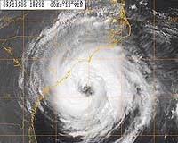
Hurricanes can completely re-structure themselves inside, and that presents forecasters with great uncertainty when predicting their effects on the general population. |
|
| The content herein, unless otherwise known to be public domain, are Copyright 1995-2006 - SpaceDaily.AFP and UPI Wire Stories are copyright Agence France-Presse and United Press International. ESA PortalReports are copyright European Space Agency. All NASA sourced material is public domain. Additionalcopyrights may apply in whole or part to other bona fide parties. Advertising does not imply endorsement,agreement or approval of any opinions, statements or information provided by SpaceDaily on any Web page published or hosted by SpaceDaily. Privacy Statement |