|
Seattle WA (SPX) Aug 05, 2004 Mayor Greg Nickels today officially launched the Puget Reference Station Network (PRSN), a regional Global Positioning System (GPS) network, which covers 1,600 square miles and will provide significant benefits for Seattle and the surrounding regions. Using technology developed by Trimble, the PRSN will supply centimeter-level, real-time GPS data to government agencies, emergency managers, research institutions, scientific agencies, and private surveying and mapping professionals for a variety of applications including surveying, field inventory, construction, disaster response and scientific research. "This groundbreaking network will save taxpayers in Seattle and the region millions of dollars by reducing costs for surveys, civil engineering and construction projects," said Nickels. "The network will also improve response time to disasters like earthquakes and provide data for seismic research." The 10-station network is an extension of a four-year pilot project undertaken by Seattle Public Utilities (SPU); the pilot network was a four- station Trimble VRS (Virtual Reference Station) network. The VRS enables users to take precise readings over much greater distances with fewer reference stations. Due to the scalable nature of the technology, the network can continue to grow as needs and coverage area increases. There are plans to expand the network to 32 stations covering 12,000 square miles throughout western Washington and then to 80 stations statewide. "Virtual Reference Station technology is fundamentally changing the way surveyors and engineers measure our world, and Trimble is very happy that the City of Seattle, and the other PRSN partners have joined this advanced positioning revolution," said Jeff Hamilton, Global Infrastructure manager for Trimble's Geomatics and Engineering Business. "In most major metro areas there are projects that go on for miles: highway corridors, pipelines, communication infrastructures and mass transit systems," said Gavin Schrock, SPU survey and GIS analyst. "PRSN enables us all to be on a precise grid, improving communication, data sharing and project management while potentially reducing costs." The City of Seattle has partnered with the City of Renton; Kitsap Public Utility District (PUD); Washington Department of Transportation (WSDOT); Snohomish, King, Pierce, Thurston, Island and Skagit Counties; University of Washington (UW) and Central Washington University (CWU); the National Oceanic Atmospheric Administration (NOAA); and the National Geodetic Survey (NGS). Community Email This Article Comment On This Article Related Links Trimble SpaceDaily Search SpaceDaily Subscribe To SpaceDaily Express GPS Applications, Technology and Suppliers
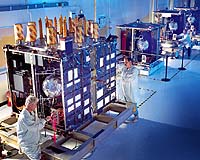
 Cheltenham, England (SPX) Jan 09, 2006
Marotta UK is pleased to announce that it designed, developed and qualified equipment for the cold gas propulsion systems on board the Galileo GIOVE-A, part of Europe's Galileo navigation program, successfully launched by Surrey Satellite Technology (SSTL). |
|
| The content herein, unless otherwise known to be public domain, are Copyright 1995-2006 - SpaceDaily.AFP and UPI Wire Stories are copyright Agence France-Presse and United Press International. ESA PortalReports are copyright European Space Agency. All NASA sourced material is public domain. Additionalcopyrights may apply in whole or part to other bona fide parties. Advertising does not imply endorsement,agreement or approval of any opinions, statements or information provided by SpaceDaily on any Web page published or hosted by SpaceDaily. Privacy Statement |