|
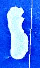
Washington - September 7, 1999 - A NASA satellite instrument is keeping an eye on an iceberg the size of Rhode Island, the first time this space technology has been used to track a potential threat to international shipping. NASA's new orbiting SeaWinds radar instrument, flying aboard the QuikScat satellite, will monitor Iceberg B10A, which snapped off Antarctica seven years ago and has since drifted into a shipping lane. Iceberg B10A, which measures about 24 miles by 48 miles, was spotted by the instrument during its first pass over Antarctica, demonstrating SeaWinds' all-weather and day-night observational capabilities. The massive iceberg extends about 300 feet above water and may reach as deep as 1,000 feet below the ocean's surface. It is breaking up into smaller pieces that could pose a threat to commercial, cruise and fishing ships if the pieces are blown back into the shipping lane by high winds. "Although the iceberg isn't posing a threat to ships in the area right now, pieces of B10A could be blown back into the shipping lane and become a danger to ships using the Antarctic's Drake Passage," said Dr. David Long, a member of the SeaWinds science team from Utah's Brigham Young University, Provo, UT. Long added that the SeaWinds instrument will be able to help scientists at the National Ice Center, Suitland, MD, track pieces of the iceberg down to about 2.5 miles in size. B10A, which took hundreds of thousands of years to form, broke off the end of the Thwaites glacier of Antarctica in 1992, and has been drifting in the ocean ever since, driven by ocean currents and wind. In 1995, the iceberg broke in half, but was being tracked on a regular basis. Although conventional methods of tracking sea-surface ice -- using ships' radar, shipping reports, optical images from satellites and microwave sensor data -- are usually sufficient for tracking large pieces of ice, icebergs can sometimes disappear in the poor visibility of dark, cloudy Antarctic winters. "That happened earlier this year, when we lost track of B10A's exact whereabouts," Long said. "Even though a ship was dispatched to the iceberg's last known position, we were unable to find it until we started receiving data from the SeaWinds instrument in July." Scientists were surprised at its location when they found B10A, but it was clearly identified as a very large iceberg that posed a considerable threat to ships in the area. A check with the Naval Ice Center confirmed the iceberg's identity and has enabled scientists to continue tracking its journey through the Drake Passage. When it was rediscovered earlier this month heading northeast between Tierra del Fuego at the southern tip of South America and the Antarctic Peninsula, the National Ice Center issued an iceberg navigation warning to the Argentine government. Ironically, the iceberg that took many millennia to form is expected to break up within about three months because it is drifting into warmer waters.
"We will be able to watch the iceberg's breakup for the first time with daily radar observations and better understand the effects of ocean winds and climate on melting polar ice," Long said. "The polar regions play a central role in regulating global climate and it is important to accurately record and monitor the extent and surface conditions of Earth's major ice masses," said Long.
QuickSat At SpaceDaily
Email This Article Comment On This Article Related Links Space
 Calcutta, India (SPX) Dec 28, 2005
The successful launch Thursday of India's heaviest satellite from spaceport of Kourou in French Guyana may have boosted the country's space research efforts to yet another level, but it has also lifted the spirits of at least three Direct-To-Home televisions broadcasters, one of which has been waiting for years to launch its services in India. |
|
|
|
|
|
|
|
|
|
|
|
|
|
| The content herein, unless otherwise known to be public domain, are Copyright 1995-2006 - SpaceDaily.AFP and UPI Wire Stories are copyright Agence France-Presse and United Press International. ESA PortalReports are copyright European Space Agency. All NASA sourced material is public domain. Additionalcopyrights may apply in whole or part to other bona fide parties. Advertising does not imply endorsement,agreement or approval of any opinions, statements or information provided by SpaceDaily on any Web page published or hosted by SpaceDaily. Privacy Statement |