|
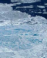
Greenbelt - Oct 03, 2003 NASA researchers and other scientists used a satellite combined with aircraft video to create a new technique for detecting ponds of water on top of Arctic sea ice. Until now, it was not possible to accurately monitor these ponds on ice from space. Water that forms on sea ice during the summer, called a melt pond, absorbs the Sun's energy rather than reflecting it back to space the way ice does. The balance between reflected and absorbed energy has a large effect on Arctic and global climate. When more ponds of water form on the Arctic sea ice cover in early summer, more heat is absorbed, causing the Arctic's sea ice cover to melt faster during the summer. Knowledge of when and where these melt ponds form will help scientists calculate the balance of energy in the Arctic and improve their knowledge and projections of climate both regionally and globally. By using detailed aircraft video of Arctic surfaces and comparing those with coarser satellite imagery, the researchers were able to recognize rough features in the satellite data that corresponded to ponds on ice, ocean water, and un-melted sea ice. Now, they are able to use a satellite to monitor sea ice, without the aid of the aircraft video. Satellites offer the advantages of frequent regular flyovers that cover vast areas all at once. "Our new technique offers the possibility of determining when and mapping where these melt ponds form and would greatly aid our understanding of the Arctic heat balance," said co-author Donald Cavalieri, a senior research scientist at NASA's Goddard Space Flight Center (GSFC), Greenbelt, Md. An article describing the new technique appeared in a recent issue of the journal, Remote Sensing of Environment. During spring and summer, these melt ponds cause existing sea ice to melt faster and greatly reduce the ice's ability to reflect sunlight. This can create a positive feedback, where an increasing number of melt ponds absorbs more heat and causes sea ice cover to melt even faster. During the warmer months, melt ponds can cover up to 50 percent of the Arctic sea ice area. There may be a relationship between the fraction of melt ponds and the amount of sea ice cover at summer's end. Researchers know from satellite records covering the last 30-years that the Arctic sea ice cover at summer's end has been decreasing rapidly. This new technique may help them determine whether there has also been an increase in the number of melt ponds over this period. This new technique to detect melt pond coverage uses NASA's Enhanced Thematic Mapper Plus (ETM+) instrument on the Landsat 7 satellite, developed with the aid of much higher resolution video imagery from a NASA supported aircraft experiment during the summer of 2000. "This result is an excellent example of how the coordinated use of satellites and research aircraft are used to develop new techniques for observing the Earth," Cavalieri added. By using video footage from an aircraft flight at an altitude of almost one and a half kilometers, the researchers were able to compare that higher resolution footage with Landsat 7 images passing over the same path above Baffin Bay in the Arctic on the same day. They then compared the Landsat imagery with the aircraft video. While Landsat 7 shows less detail, it covers vast areas all at once. The aircraft video, on the other hand, allows researchers to view a 1.5 meter area in detail. By classifying 13 high resolution images from the aircraft into areas of ocean, ice with ponds, and pond-free ice and then comparing these areas with the different wavelength bands of Landsat, the researchers were able to develop a new method to calculate the extent of open water, melt ponds, and sea ice over large areas using Landsat data by itself. "Previously there were no systematic measurements of melt ponds, but this technique with the Landsat creates the possibility of determining when and where these melt ponds form," Cavalieri said. "It helps us understand the heat balance, which ties into the global climate system." Lead author Thorsten Markus, who is currently conducting research at sea, is also a scientist at NASA GSFC. Other co-authors include Mark Tschudi, National Center for Atmospheric Research, Boulder, Colo., and Alvaro Ivanoff, Science Systems and Applications, Inc., Lanham, Md. The study was funded by NASA. NASA's Earth Science Enterprise is dedicated to understanding the Earth as an integrated system and applying Earth System Science to improve prediction of climate, weather, and natural hazards using the unique vantage point of space. Community Email This Article Comment On This Article Related Links SpaceDaily Search SpaceDaily Subscribe To SpaceDaily Express Dirt, rocks and all the stuff we stand on firmly
 Paris (ESA) Jan 12, 2006
Using the ESA Cluster spacecraft and the NASA Wind and ACE satellites, a team of American and European scientists have discovered the largest jets of particles created between the Earth and the Sun by magnetic reconnection. This result makes the cover of this week's issue of Nature. |
|
| The content herein, unless otherwise known to be public domain, are Copyright 1995-2006 - SpaceDaily.AFP and UPI Wire Stories are copyright Agence France-Presse and United Press International. ESA PortalReports are copyright European Space Agency. All NASA sourced material is public domain. Additionalcopyrights may apply in whole or part to other bona fide parties. Advertising does not imply endorsement,agreement or approval of any opinions, statements or information provided by SpaceDaily on any Web page published or hosted by SpaceDaily. Privacy Statement |