|
Arlington - May 07, 2003 From the air and the ground, scientists this spring and summer will examine some of the world's largest thunderstorm complexes, behemoths that can spread hurricane-force wind and torrential rain for hundreds of miles across the U.S. Midwest. The study, scheduled from May 20 to July 6, should provide the clearest picture to date of how such storms wreak havoc and how forecasters can better predict trails of storm damage. The Bow Echo and MCV Experiment (BAMEX) is organized by scientists Christopher Davis and Morris Weisman at the National Center for Atmospheric Research (NCAR) in Boulder, Colo. MCV stands for mesoscale convective vortex, a low-pressure center associated with large clusters of storms. The $4 million study is funded primarily by the National Science Foundation (NSF). Collaborators include the National Oceanic and Atmospheric Administration (NOAA), the Naval Research Laboratory, and a dozen colleges and universities (listed below). The BAMEX study area encompasses most of the Midwest. Field operations, including three aircraft and a forecast center, are based at MidAmerica Airport, just east of St. Louis. Mobile weather labs will traverse the study area. Ron Przybylinski of NOAA's National Weather Service (NWS) office in St. Louis says forecasters in the region are eager to participate in BAMEX, which is the area's biggest thunderstorm-related study since the 1970s. "This is a once-in-a-lifetime experience. The more knowledge we have about the evolution of these systems, the better we can predict them." Unlike many summer storms that develop and decay in an hour or two, mesoscale convective systems�which can produce bow echoes and MCVs�are often large, intense and long lasting. Typically, such a system develops in the warmth of the late afternoon and can last through the night. As it grows, a downdraft of high winds from rain-cooled air can push it into a bow-like configuration, seen as a bow echo on radar. Weak tornadoes may form along the bow or at either end, but the main threat is from straight-line winds that can gust to over 100 miles per hour. While a typical tornadic thunderstorm might span 12 miles, the long-lived systems studied in BAMEX can stretch more than 90 miles in width and carve paths more than 500 miles long. Such storms can be terrifying, especially late at night when they are most likely to occur across much of the Midwest. On the night of July 26, 1990, a bow echo barreled through Kansas City packing winds of 74 mph. The storm ripped off roofs, downed trees and cut electric power to about 100,000 homes and businesses. Between January 1995 and July 2000, high winds from U.S. mesoscale convective systems caused over $1.4 billion in damage, 72 deaths and over 1,000 injuries. BAMEX will study how these damaging winds unfold at night, when low-level air usually cools and stabilizes. After a mesoscale convective system dissipates, its vortex may persist as a focus for new storms the next day, making the vortex a potential forecasting tool. Several days of storms can be triggered as an MCV makes its way across the central and eastern United States. "This characteristic of an MCV is most interesting, as it implies a greater degree of predictability in storm initiation than previously thought possible," says Steve Nelson, program director for mesoscale meteorology at NSF. Heavy rain is a particular threat with these multi-day episodes. One July 1977 MCV that formed in South Dakota ended up producing a catastrophic flood in Johnstown, Pa., killing 78 people. Although researchers have made progress simulating mesoscale convective systems with computer models, there have been no large-scale experiments in recent years aimed at gathering data on these enormous complexes. According to Weisman, "We came to realize that we'd gone about as far as we could with the idealized simulations. We needed to get good data." During BAMEX, three research aircraft will track developing bow echoes and MCVs as they move east across the Midwest from South Dakota, Nebraska, and Kansas to the Ohio Valley. Two of the aircraft have Doppler radar on board. A third will release dropsondes�instrument packages that sample the atmosphere and transmit weather data as they gently descend via parachute. Ground-based crews will intercept the storms in mobile weather laboratories, deploying weather balloons and using atmospheric profilers and other instruments to sample the storm environment. "It's going to be unique in that we'll be all over the place and never know where we'll be the next night," says NCAR's Ned Chamberlain, who is overseeing the balloon launches. "We'll be driving hundreds of miles in a day." To capture the nighttime phase of the mesoscale systems, each day's activity could extend from four o'clock in the afternoon to two o'clock in the morning. Forecasters from NWS offices throughout the Midwest will take turns sharing their expertise in St. Louis, examining computer models and diagnosing storm behavior. The data gleaned from BAMEX should enable forecasters to improve their warnings for the high winds produced by bow echoes and the heavy rains triggered by MCVs. The Joint Office for Science Support (JOSS)�part of the University Corporation for Atmospheric Research, which operates NCAR�has built a Web-based catalog to provide up-to-the-minute field data and serve as an archive for later use. JOSS is also teaming with NCAR and other participants to set up and staff the BAMEX operations center. The project will benefit greatly from the expertise of the NWS forecasters on hand, according to JOSS's James Moore. "We expect to take advantage of their local knowledge and appreciation for these strong mesoscale systems. They'll be a real asset," he said. Community Email This Article Comment On This Article Related Links National Oceanic and Atmospheric Administration SpaceDaily Search SpaceDaily Subscribe To SpaceDaily Express Dirt, rocks and all the stuff we stand on firmly
 Greenbelt - Jan 21, 2004
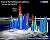
They are called hurricanes in the Atlantic, typhoons in the West Pacific, and tropical cyclones worldwide; but wherever these storms roam, the forces that determine their severity now are a little less mysterious. NASA scientists, using data from the Tropical Rainfall Measuring Mission (TRMM) satellite, have found "hot tower" clouds are associated with tropical cyclone intensification. |
|
| The content herein, unless otherwise known to be public domain, are Copyright 1995-2006 - SpaceDaily.AFP and UPI Wire Stories are copyright Agence France-Presse and United Press International. ESA PortalReports are copyright European Space Agency. All NASA sourced material is public domain. Additionalcopyrights may apply in whole or part to other bona fide parties. Advertising does not imply endorsement,agreement or approval of any opinions, statements or information provided by SpaceDaily on any Web page published or hosted by SpaceDaily. Privacy Statement |