|
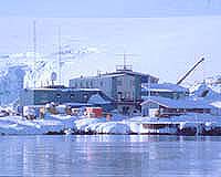
Palmer Station, Antartica (SPX) Jun 13, 2005 Using inflatable boats, a portable depth sounder with GPS, and a REMUS autonomous underwater vehicle, a team of scientists and engineers has created the first detailed, comprehensive chart of the ocean floor around Palmer Station in Antarctica, revealing previously unknown submerged rocks. The new chart, the first in 50 years, was made by a research team from the Woods Hole Oceanographic Institution (WHOI) and the University of Southern Mississippi over five weeks in April and early May as they looked for sites for a new underwater observatory. Their findings revealed a number of previously unmapped submerged rocks, among them a set of sharp rocky pinnacles that are potential navigational hazards. Some rise nearly 100 meters (about 330 feet) to a depth of six meters (about 20 feet) below the surface and near to the routes generally taken by ships through the area. The previous nautical chart of the area was produced in the mid 1900's by single soundings taken at very wide spacing. Although some underwater hazards were marked on the earlier chart, the old chart was found to be incorrect by at least 0.5 nautical miles (just under one mile). Since Palmer Station was first established as a scientific outpost in 1965, ships have followed a particular route through the visible rocks. In typical marine navigation in poorly charted waters, ships new to the area proceed cautiously, making continuous soundings with their bridge fathometer. They then note their routes on charts and follow the same routes when entering and departing the area. "We were astounded to find these rocks so close to the surface and the shipping lanes," said Scott Gallager, an associate scientist in the Biology Department of the Woods Hole Oceanographic Institution. "When you think of all the ship traffic that has passed through the area through the years and the often hostile weather conditions, you realize how skillful and lucky they have been." Gallager and co-principal investigator Vernon Asper of the University of Southern Mississippi conducted the survey with WHOI engineers Keith von der Heydt and Gregory Packard. Funding was provided by the National Science Foundation�s Office of Polar Programs. Palmer Station is at 64�46' S, 64�03' W, on protected Arthur Harbor on the southwestern coast of Anvers Island, about midway down the Antarctica Peninsula. Palmer is one of three U.S. research stations on the continent and the only station north of the Antarctic Circle. Named for American sealer Nathaniel B. Palmer, who in 1820 was one of the first to see Antarctica, the station was built in 1968 to replace the prefabricated wood huts of 'Old Palmer' station, established in 1965. In 1990 Palmer Station was designated by the National Science Foundation as a long term ecological research (LTER) site. Most researchers travel to the station from Punta Arenas, Chile across the Drake Passage aboard the research vessels Laurence M. Gould and Nathaniel B. Palmer, operated by the National Science Foundation for the Antarctic research community. In light of the new information, the Gould and the Palmer are now using modified access routes into Palmer Station to give a wider berth to the newly imaged rock hazards. Gallager, Asper and their team went to survey the sea floor around Palmer Station to locate possible sites for the installation of the first underwater cabled observatory in Antarctica. The Polar Remote Interactive Marine Observatory (PRIMO) will be equipped with sensors to monitor ocean properties during an entire year. It will be installed in the Austral fall of 2006 about two nautical miles to the south of Palmer Station on the ocean bottom at a depth of approximately 130 meters (425 feet), connected by a fiber-optic and electrical cable to a newly constructed building at Palmer Station. Instruments, including current meters, plankton imaging systems, and an under ice video observation system, will travel up and down through the water column throughout the day from the observatory�s base to just below the surface, even after the pack ice forms and covers the area. Proximity sensors on the top of the profiling platform will send and receive acoustic signals to prevent it from contacting the ice. The scientists hope to use this first observatory as a proof of concept and test-bed for a similar observatory to be located in deeper water. Other scientists, students and educators around the world will be able to access PRIMO via the Internet and conduct experiments related to plankton distributions, carbon cycling, and climate change. "Protection of the cable and underwater platform from grounding icebergs at depths of 100 meters (330 feet) or greater is a major concern, and the primary reason for needing the detailed underwater maps, but finding the rocks was an unexpected bonus of the trip," said Gallager. "The real challenge now is to design and build a platform that will survive the harsh Antarctic winters in the water and provide us the first ever long-term, high resolution glimpses of what is going on in this region of the Southern Ocean. That will be exciting!" Community Email This Article Comment On This Article Related Links SpaceDaily Search SpaceDaily Subscribe To SpaceDaily Express Nuclear Space Technology at Space-Travel.com
 Edmonton AB (SPX) Jan 10, 2006
Although the story on glacier fluctuations in northwestern North America over the last 10,000 years has remained largely unchanged for decades, new evidence discovered by a University of Alberta researcher will rewrite that glacial history and offer clues about our climate history during the last several thousand years. |
|
| The content herein, unless otherwise known to be public domain, are Copyright 1995-2006 - SpaceDaily.AFP and UPI Wire Stories are copyright Agence France-Presse and United Press International. ESA PortalReports are copyright European Space Agency. All NASA sourced material is public domain. Additionalcopyrights may apply in whole or part to other bona fide parties. Advertising does not imply endorsement,agreement or approval of any opinions, statements or information provided by SpaceDaily on any Web page published or hosted by SpaceDaily. Privacy Statement |