|
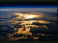
Boulder - Aug 23, 2002 A revolutionary, globe-spanning satellite network will furnish round-the-clock weather data, monitor climate change, and improve space weather forecasts by intercepting signals from the Global Positioning System (GPS). Using atmosphere-induced changes in the radio signals, scientists will infer the state of the atmosphere above some 3,000 locations every 24 hours, including vast stretches of ocean inadequately profiled by current satellites and other tools. Nearly 100 scientists from over a dozen countries are meeting in Boulder on August 21--23 to help plan the use of data from this $100 million mission, which will begin operations in 2005. Called COSMIC, the satellite network is now being developed through a U.S.-Taiwan partnership based on a system design provided by the University Corporation for Atmospheric Research, where the COSMIC Project Office is based. Taiwan's National Science Council and National Space Program Office (NSPO) and the U.S. National Science Foundation are providing primary support for COSMIC. "The increased coverage will improve weather forecasts by providing data where there previously was none or not enough," says Ying-Hwa Kuo, project director for the Constellation Observing System for Meteorology, Ionosphere and Climate (COSMIC), also called ROCSAT-3 in Taiwan. With six satellite receivers, COSMIC will collect a global, 3-D data set expected to improve analyses of both weather and climate change. By tracking temperature in the upper atmosphere up to 30 miles high, COSMIC could help clarify whether these regions are cooling due to heat-trapping greenhouse gases closer to the surface. COSMIC will also measure high-altitude electron density, potentially enhancing forecasts of ionospheric activity and "space weather." COSMIC's satellites will probe the atmosphere using radio occultation, a technique developed in the 1960s to study other planets but more recently applied to Earth's atmosphere. Each satellite will intercept a GPS signal after it passes through (is occulted by) the atmosphere close to the horizon. Such a path brings the signal through a deep cross-section of the atmosphere. Variations in electron density, air density, temperature, and moisture bend the signal and change its speed. By measuring these shifts in the signal, scientists can determine the atmospheric conditions that produced them. The result: profiles along thousands of angled, pencil-like segments of atmosphere, each about 200 miles long and a few hundred feet wide. Rather than replacing other observing systems, COSMIC will blend with them, filling in major gaps and enhancing computer forecast models. Many satellite-based products are like topographic maps that trace the contours of atmospheric elements in a given height range with high horizontal precision. COSMIC is more akin to a set of probes that drill through the depth of atmosphere with high vertical precision. Thus, says Kuo, "COSMIC will complement the existing and planned U.S. meteorological satellites." Radiosondes (weather sensors launched by balloon) have obtained vertical profiles since the 1930s. However, they are launched only twice a day in most spots, and few are deployed over the ocean. In contrast, the COSMIC data will be collected continuously across the globe. The GPS radio signals can be picked up by the low-orbiting COSMIC receivers even through clouds, which are an obstacle for satellite-borne instruments that sense infrared rays of the spectrum. UCAR and colleagues began exploring the use of GPS-based observing systems in 1995 with the successful launch of a test satellite. Several other systems have been launched by researchers in the United States, Germany, and Argentina. All of these are research-based systems, with the data made available within days or weeks. COSMIC's data will be available within three hours of the observations, making them a potential boon to everyday forecast operations. The COSMIC Project Office will serve as a clearinghouse for research use of the data from COSMIC and other GPS-based systems by scientists in the U.S., Taiwan, and elsewhere. UCAR is overseeing ground-based facilities, satellite payloads, launch services, and data processing structures for COSMIC. Orbital Sciences Corporation is responsible for spacecraft design. The first spacecraft will be built at Orbital's facilities in Dulles, Virginia. The rest of the constellation will be built and tested in Taiwan, where the system's mission control will be based. NSPO and Taiwan industrial partners will join in satellite system development. Other collaborators include NASA, the National Oceanic and Atmospheric Administration, the Air Force, Jet Propulsion Laboratory, and Naval Research Laboratory. Community Email This Article Comment On This Article Related Links Constellation Observing System for Meteorology, Ionosphere and Climate SpaceDaily Search SpaceDaily Subscribe To SpaceDaily Express Earth Observation News - Suppiliers, Technology and Application
 New York NY (SPX) Jan 11, 2006
The importance of remotely sensed data and technologies to support natural disasters has prompted attention and action in Washington. New initiatives and legislation authorizing appropriations to the remote sensing industry will be discussed at Strategic Research Institute's U.S. Commercial Remote Sensing Industry conference, scheduled for February 9-10, 2006 in Washington D.C. |
|
| The content herein, unless otherwise known to be public domain, are Copyright 1995-2006 - SpaceDaily.AFP and UPI Wire Stories are copyright Agence France-Presse and United Press International. ESA PortalReports are copyright European Space Agency. All NASA sourced material is public domain. Additionalcopyrights may apply in whole or part to other bona fide parties. Advertising does not imply endorsement,agreement or approval of any opinions, statements or information provided by SpaceDaily on any Web page published or hosted by SpaceDaily. Privacy Statement |