|
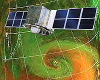
Beijing (SPX) Apr 30, 2004 A high-ranking Chinese space official Tuesday said the nation will launch a cluster of small satellites to allow better disaster management from space. "Through the establishment of a small satellite constellation consisting of multiple small remote-sensing satellites, our capacity in applying space technology in disaster mitigation and environmental monitoring will be improved," said Luan Enjie, administrator of the China National Space Administration (CNSA) at a High-level Panel on Knowledge Economic Development. "Large-scale, all-weather, all-time and dynamic monitoring of the environment and disasters will be realized to contribute to the sustainable economic and social development of China," he said. According to Luan, the main mission of the small satellite constellation will be to monitor the environment for floods, drought, typhoons, wind storms and tidal events. The system can also sense earthquakes, landslides, mud-rock flows, forest fires, plant diseases and insect pests, sea disasters, environmental pollution and assess disaster management. "The system will mainly follow the development of natural disasters and allow forecasting," said Luan. While it may not directly improve the accuracy of earthquake forecasts, Luan is confident the information and data it collects will contribute to related research. The first stage of the project, upon which research started five years ago, includes the launch of three satellites, -- two small optical satellites and one small synthetic aperture radar satellite -- by 2006 with China's own capacity. With a period of 48 hours, the satellites will meet part of the demand for disaster management. With international co-operation, the system will have been expanded by 2010 to a second stage, which includes eight satellites -- four optical satellites and four radar ones -- with a shortened period of 12 hours. By then, the all-weather and all-time monitoring in a real sense will be materialized. The system, when completed, will be the first in the region to be directed specifically towards natural disaster evaluation. "We are willing to make the small satellite constellation one of the platforms for disaster mitigation in the Asia-Pacific region and to actively promote the application of space technology for disaster control in China and other countries in the region to reduce costs and risks, and share resources," said Luan. Luan later told the media that the first three satellites are currently under research and production. "There are very few satellite systems that are specifically collecting the kind of data that are required for disaster research. This is something unique about the Chinese system," said Allen Clark, executive director of the Hawaii-based Pacific Disaster Centre. Describing the system as "extremely valuable," Clark told China Daily that his agency will be "very interested in taking the data and information (collected by the system) and establishing the network within the region for the use in disaster management." According to Luo Ge, director-general of the CNSA's Department of Foreign Affairs, China has contacted a number of countries, including Russia, India, Indonesia, Malaysia, Peru and Brazil concerning co-operation. "All of them are very interested," said Luo. China's space technology has attracted the world's attention with high successful rates of satellite launches and, in particular, with its status as the third country after Russia and the United States to send a human being into space. Like many other countries in the region, China is plagued by various kinds of natural disasters every year, such as floods, drought, earthquakes, typhoons and landslides. About 200 million people are affected annually and economic losses caused by natural disasters amount to 2 to 5 per cent of the gross national product (GNP). In 2003, natural disasters caused a economic losses of 188.42 billion yuan (US$22.7 billion). Luan Tuesday also expressed China's willingness to take part in regional and international space co-operation in disaster management. The countries in the Asia-Pacific region should establish a regional co-ordination mechanism for space technology-based disaster mitigation and strengthen co-operation, Luan suggested, adding that they also need to set up an all-weather and all-time comprehensive space-based disaster mitigation system and share information. He pledged that China will provide necessary technical assistance when major natural disasters occur and make full use of the nation's resources to provide training for space technology-based disaster mitigation and control to developing countries. Source: Xinhua News Agency Community Email This Article Comment On This Article Related Links SpaceDaily Search SpaceDaily Subscribe To SpaceDaily Express Earth Observation News - Suppiliers, Technology and Application
 New York NY (SPX) Jan 11, 2006
The importance of remotely sensed data and technologies to support natural disasters has prompted attention and action in Washington. New initiatives and legislation authorizing appropriations to the remote sensing industry will be discussed at Strategic Research Institute's U.S. Commercial Remote Sensing Industry conference, scheduled for February 9-10, 2006 in Washington D.C. |
|
| The content herein, unless otherwise known to be public domain, are Copyright 1995-2006 - SpaceDaily.AFP and UPI Wire Stories are copyright Agence France-Presse and United Press International. ESA PortalReports are copyright European Space Agency. All NASA sourced material is public domain. Additionalcopyrights may apply in whole or part to other bona fide parties. Advertising does not imply endorsement,agreement or approval of any opinions, statements or information provided by SpaceDaily on any Web page published or hosted by SpaceDaily. Privacy Statement |