|
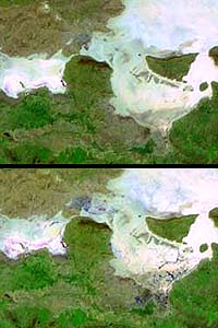
Greenbelt - Feb 12, 2003 The unique capabilities of a NASA earth-observing satellite have allowed researchers to view the effects of a major earthquake that occurred in 2001 in Northern India near the border of Pakistan. Lead author Bernard Pinty of the Institute for Environment and Sustainability in the Joint Research Centre of the European Commission, Ispra, Italy, and colleagues from the U.S., France and Germany, used the Multi-angle Imaging SpectroRadiometer (MISR) instrument on NASA's Terra satellite to observe the effects of a massive earthquake in the Gujarat province of India. Considered one of the two most damaging seismic events in Indian recorded history, the Gujarat earthquake struck with a magnitude of 7.7 (Richter scale) on January 26, 2001. About 20,000 people died and another 16 million people were affected. Local residents reported fountains of water and sediments spouting from the Earth following the earthquake. As a result of the earthquake's intense ground shaking, loosely-packed, water-saturated sediments in the area liquefied, behaving more like a liquid than a solid. Ground water flowed up to the surface carrying sediments, flooding large areas including ancient riverbeds. "Although the instrument's multiangle and multispectral capabilities weren't specifically developed for the purpose of detecting surface water, this is an exciting application that merits further investigation," said co-author David J. Diner, MISR Principal Investigator at NASA's Jet Propulsion Laboratory, Pasadena, Calif. "Of significance to the Gujarat event is MISR's acquisition of compelling evidence of surface water far from the earthquake's epicenter, particularly over remote locations inaccessible to teams on the ground." Aside from collecting scientific data in hard to reach places, MISR also provides a map overview of what happened and the area affected. Such information could be used to detect places where survey teams could concentrate their efforts. In this case, MISR data demonstrated that specific areas of the Rann were more affected than others by dewatering. In addition, the data were instrumental in identifying distant sites of liquefaction. Such information may help to validate earthquake models and to further constrain relationships between earthquake magnitudes and distances of impacts. "Satellites provide the best way to have a global view of an entire region, hundreds of square kilometers can be observed in a few minutes, and this happens at any time they fly over a place," said Pinty. "In the case of Gujarat, scientists were able to conduct surveys near the epicenter but could hardly access other regions also affected by the earthquake, partly because of the proximity of Pakistani border, a high security and politically sensitive region." The earthquake's epicenter was located about 80 kilometers (50 miles) east of the city of Bhuj, but the MISR instrument found dewatering, or release of water and sediment due to compression and liquefaction, as far as 200 km (124 miles) from the epicenter. Additionally, there was significant dewatering all along an 80-100 kms (50-62 miles) wide (south to north) ancient salt lake bed to the north of Bhuj, known as the Rann of Kutch. In the days to weeks following the earthquake, along with ground cracks and other types of deformation, water flowed to the surface and progressively evaporated in various places. A year later, scientists could still observe the consequences of the earthquake across the Rann because the water that came up to the surface was very salty. After evaporation, the salt was left on the ground and MISR was able to detect it also. The MISR instrument views the sunlit face of the Earth simultaneously at nine widely spaced angles, and provides ongoing global coverage with high spatial detail. Its imagery is carefully calibrated to provide accurate measurements of the brightness, contrast, and color of reflected sunlight. One way MISR registers surface features is by picking up different wavelengths of light as they are reflected off the Earth's surface. As the satellite passes overhead, MISR collects information over a 400 km (248 mile) swath at a spatial resolution of 275 meters (300 yards), instantaneously assessing surface features over large regions. Since the bright soils of the Rann of Kutch reflect most of the Sun's incoming near-infrared radiation, and water bodies absorb near-infrared radiation, MISR can detect the contrast and thereby tell where dewatering from the earthquake occurred. Changes in reflection at different view angles also proved advantageous to identify the presence of surface water in other regions. Community Email This Article Comment On This Article Related Links SpaceDaily Search SpaceDaily Subscribe To SpaceDaily Express Tectonic Science and News
 Sydney (AFP) Dec 12, 2005
Thousands of tonnes of ash are continuing to spew from a volcano in Vanuatu, but officials said Monday the activity on the South Pacific nation was not likely to result in a major deadly eruption. |
|
| The content herein, unless otherwise known to be public domain, are Copyright 1995-2006 - SpaceDaily.AFP and UPI Wire Stories are copyright Agence France-Presse and United Press International. ESA PortalReports are copyright European Space Agency. All NASA sourced material is public domain. Additionalcopyrights may apply in whole or part to other bona fide parties. Advertising does not imply endorsement,agreement or approval of any opinions, statements or information provided by SpaceDaily on any Web page published or hosted by SpaceDaily. Privacy Statement |