 |
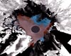
Paris, France (ESA) Nov 06, 2008 Humanitarian aid workers responding to devastating flooding in Honduras have received assistance from space, with satellite images of affected areas provided rapidly following activation of the International Charter on Space and Major Disasters. Tens of thousands of people have been displaced and 33 lives have been claimed by floods and landslides brought on by a tropical depression that hit the Central American country on 16 October. On 27 October, the UN Institute for Training and Research (UNITAR) Operational Satellite Applications Programme (UNOSAT) asked the International Charter on 'Space and Major Disasters', referred to as 'The Charter', for support. Satellite images of the area acquired by ESA's Envisat were delivered the same day. The Charter, founded in October 2000 by ESA, the French Space Agency (CNES) and the Canadian Space Agency (CSA), works to provide satellite data free of charge to those affected by disasters anywhere in the world. With inundated areas typically visible from space, Earth Observation (EO) is increasingly being used for flood response and mitigation. One of the biggest problems during flooding emergencies is obtaining an overall view of the phenomenon, with a clear idea of the extent of the flooded area. The crisis image of the Cortes Department, one of the hardest hit areas, is comprised of two Envisat radar images - one acquired on 25 October and one on 20 September that was used as a reference. The blue and red colours indicate areas that are potentially flooded. The flooding is being compared to the devastation left by Hurricane Mitch, which killed about 6 000 people when it ripped through Honduras a decade ago. Overall, Mitch claimed more than 10 000 lives across Central America. In the wake of Hurricane Mitch, ESA, CNES and Spot Image worked to provide rapid and accurate EO-based maps of the area to emergency response teams. The reaction by the space community to the impact of Mitch is considered a precursor to the Charter. Today, the Charter has 10 members, including ESA, CNES, CSA, the Indian Space Research Organisation (ISRO), the US National Oceanic and Atmospheric Administration (NOAA), the Argentine Space Agency (CONAE), the Japan Aerospace Exploration Agency (JAXA), the British National Space Centre/Disaster Monitoring Constellation (BNSC/DMC), the U.S. Geological Survey (USGS) and the China National Space Administration (CNSA). Community Email This Article Comment On This Article Share This Article With Planet Earth
Related Links UNOSAT Earth Observation News - Suppiliers, Technology and Application
 Paris, France (SPX) Oct 29, 2008
The thickness of sea ice in large parts of the Arctic declined by as much as 19% last winter compared to the previous five winters, according to data from ESA's Envisat satellite. |
|
| The content herein, unless otherwise known to be public domain, are Copyright 1995-2007 - SpaceDaily.AFP and UPI Wire Stories are copyright Agence France-Presse and United Press International. ESA Portal Reports are copyright European Space Agency. All NASA sourced material is public domain. Additional copyrights may apply in whole or part to other bona fide parties. Advertising does not imply endorsement,agreement or approval of any opinions, statements or information provided by SpaceDaily on any Web page published or hosted by SpaceDaily. Privacy Statement |
 del.icio.us
 Digg
Digg Reddit
 YahooMyWeb
 Google