|
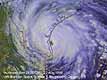
Madison - August 30, 1999 - A fleet of powerful new visualization tools is giving forecasters an unprecedented look into the anatomy of typhoons and hurricanes, helping refine early-warning systems. Beyond better resolution, these satellite-based tools are helping scientists break tropical cyclones down into their component parts, dissecting some of the forces that create, fuel and steer these dangerous storms. "What we're doing is fusing together images through the use of multiple satellites," says Chris Velden, a tropical cyclone researcher at UW-Madison. "Each satellite has its own view of the earth, and we're piecing many of them together for a more complete picture." This "data fusion" technique is the source of several new hurricane forecasting methods developed at UW-Madison that are in daily use at the National Hurricane Center in Miami and the Joint Typhoon Warning Center in Pearl Harbor. (see below for links) The bank of images is publicly available on the web site of UW-Madison's Cooperative Institute for Meteorological Satellite Studies (CIMSS) tropical cyclone team, a group led by Velden. Visitors can peruse recent and real-time movies and images of current tropical storms Dennis, Emily and Cindy, or any current cyclone in the Atlantic or Pacific Ocean. Velden says the new tools are designed to shed light on two of the biggest unknowns about tropical cyclones: Where they originate and how they gather and lose intensity. Just in the past five years, satellite technology has improved forecasting of the path of storms, but estimating their power has been difficult. One new product introduced this year, called Wavetrak, combines data from five different satellites to create a 10-day movie loop of atmospheric waves sweeping out of central Africa, the birthplace of cyclones. Wavetrak is designed to study the atmospheric waves that act as a conveyor belt for conditions that cause cyclones. "We're grappling with how and where these waves originate, because about one in every ten will form into a named tropical storm," Velden says. "This shows us the amplitude and strength of these waves as they come off Africa and into the Atlantic." Wavetrak, created by Velden and research intern Jason Dunion, gives scientists a complete picture of a cyclone -- from its birth over central Africa, growth across the Atlantic and eventual fizzling out. It shows the succession of atmospheric waves moving along "like cars on a train." The technology has great benefit in seeing the genesis of storms. "It gives us an idea of exactly where they initiate over the African continent and their convective structure as they track over the ocean." On the question of measuring tropical cyclone intensity, the CIMSS team has a number of products in use by forecasters. One product is helping provide a better handle on wind shear, an important predictor of intensity. Wind shear is essentially the difference in speed between high-level and low-lying winds. A strong wind shear will slice the tops off of cyclones and slash their power. The CIMSS site provides a multi-colored map, which uses high-resolution satellite observations updated every 3 hours, that shows the levels of wind shear across the Atlantic. It gives forecasters a highly visual record of wind shear patterns that will either break up or add fuel to a storm. Velden says scientists want to pinpoint the thresholds of wind shear effects, good or bad, on cyclones. Other CIMSS tools to track hurricane intensity include:
"We develop these tools in tandem with the forecasters," Velden says. "They know what they're looking for from us to aid the forecasting problem." CIMSS is part of UW-Madison's Space Science and Engineering Center, which specializes in atmospheric studies of earth and other planets. It is supported by NASA and the National Oceanic and Atmospheric Administration.
Email This Article Comment On This Article Related Links Space
 Calcutta, India (SPX) Dec 28, 2005
The successful launch Thursday of India's heaviest satellite from spaceport of Kourou in French Guyana may have boosted the country's space research efforts to yet another level, but it has also lifted the spirits of at least three Direct-To-Home televisions broadcasters, one of which has been waiting for years to launch its services in India. |
|
|
|
|
|
|
|
|
|
|
|
|
|
| The content herein, unless otherwise known to be public domain, are Copyright 1995-2006 - SpaceDaily.AFP and UPI Wire Stories are copyright Agence France-Presse and United Press International. ESA PortalReports are copyright European Space Agency. All NASA sourced material is public domain. Additionalcopyrights may apply in whole or part to other bona fide parties. Advertising does not imply endorsement,agreement or approval of any opinions, statements or information provided by SpaceDaily on any Web page published or hosted by SpaceDaily. Privacy Statement |