|
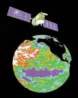
Washington DC (SPX) Apr 11, 2006 French and U.S. researchers said Tuesday they have developed an improved technique to hone satellite radar images in areas where calm or covered seas currently prevent accurate recordings. The new as-yet-unnamed method could provide more accurate ocean-surface readings and improve estimates of El Nino and La Nina events, and allow better observation and tracking of oil spills and other films on the ocean surface, the researchers said. Current satellite altimetry methods measure the height of ocean waves, but generally cannot provide accurate data when calm or slick sea-surface conditions prevail, such as from oil spills, phytoplankton blooms or lack of winds. The reason is existing radar altimetry cannot recognize the minuscule ocean waves or characteristics in a nearly stationary ocean. Calm conditions affect about 6 percent of all altimetry readings, meaning computer models must discard otherwise useful data. The researchers developed the new system artificially increases the number of altimetry signals sent to the ocean during calm conditions, in the same way that photo-enhancement software can squeeze out details in otherwise fuzzy images. "Every year, our altimeters make something like 10 million ocean measurements, so being able to recover at least a portion of that (lost data) gives us better information on sea-surface height," said team member Douglas C. Vandemark, with the University of New Hampshire's Institute for the Study of Earth, Oceans and Space. "The percentage is much higher for calmer equatorial regions such as the Pacific, which tells us about the bulge of water that controls El Nino." For example, Vandemark said, picture the Pacific Ocean as a big bathtub. A bulge in the western end - created by warm water and winds -can set off an El Nino event by creating a wave that propagates very quickly along the equator from Asia toward the Americas, eventually inducing large water temperature changes along the coasts of South and North America. Then, when the bulge makes its inevitable and slower return, it constitutes a La Nina event. The improvement comes from a modeling technique developed by scientists that should enhance and expand the number of altimeter measurements NASA can collect in the Pacific - where El Nino originates - via its Jason-1 satellite. Jason-1, launched in 2001, is a joint mission of NASA and CNES. Altimetry works by sending 1,800 separate radar pulses per second down to Earth's surface from an altitude of about 800 kilometers (500 miles), and recording how long the echoes take to bounce back. The technique can measure sea height down to one centimeter (0.4 inch), according to lead researcher Jean Tournadre, of the French Research Institute for Exploitation of the Sea in Plouzane. Vandemark said the research has solved "the problematic subset of echoes from very smooth ocean areas," and suggested that radar altimeters now might be able to estimate the spatial extent of these smooth areas. He noted that having more accurate equatorial Pacific Ocean measurements "provides agencies like NASA and (the National Oceanic and Atmospheric Administration) more measurements for El Nino prediction and tracking." Tournadre, Vandemark and colleagues published their research in the April 11 issue of the Journal of Geophysical Research-Oceans, which is published by the American Geophysical Union. Community Email This Article Comment On This Article Related Links Jason 1 French Research Institute for Exploitation of the Sea EOS American Geophysical Union Earth Observation News - Suppiliers, Technology and Application
 Falmouth MA (SPX) Apr 12, 2006
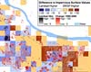
Researchers have developed new high-resolution satellite maps of the urbanization and other development surrounding the Chesapeake Bay watershed, in an attempt to help guide future land-use plans and policy. |
|
| The content herein, unless otherwise known to be public domain, are Copyright 1995-2006 - SpaceDaily.AFP and UPI Wire Stories are copyright Agence France-Presse and United Press International. ESA PortalReports are copyright European Space Agency. All NASA sourced material is public domain. Additionalcopyrights may apply in whole or part to other bona fide parties. Advertising does not imply endorsement,agreement or approval of any opinions, statements or information provided by SpaceDaily on any Web page published or hosted by SpaceDaily. Privacy Statement |