|
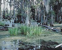
Columbus OH (SPX) Dec 18, 2006 Ohio State University researchers have demonstrated that a satellite radar system can be used to gauge water levels in vegetated wetlands. C.K. Shum, professor of earth sciences at Ohio State, and his colleagues hope to develop the technique to aid studies of wetland hydrology -- including the role that wetlands play in quelling storm surges caused by large hurricanes. They examined data from the TOPEX/Poseidon satellite, taken from four selected sites around Louisiana from 1992-2002. Using an innovative data processing technique, called "retracking," they were able to remove signal errors such as those caused by wetland vegetation. TOPEX/Poseidon measures the altitude of objects with radar. Since 1992, the joint mission of NASA and the French Space Agency has used this technology, called altimetry, to measure global sea height. In the Ohio State study, the radar altimeter signal showed that water levels were rising in some Louisiana wetlands and dropping in others -- results which agreed with available water-level gauges on the ground. Graduate student Hyongki Lee developed the technique to chart how the wetland water level changed over the ten years. He presented the results in a poster session Tuesday, December 12, 2006 at the American Geophysical Union annual meeting in San Francisco. This preliminary study doesn't say much about the general state of the Louisiana wetlands, but it does reveal water level changes in selected sites over that decade, including changes caused by seasonal rainfall. "These kinds of observations could one day help quantify the depletion or rise of water level in wetlands. In this first study, we were mainly just trying to show that the technique works," Lee said. Wetlands pose two challenges to radar altimeter studies, he explained. Wetland plants diffuse the radar signal, while open patches of water are often so calm that their surface reflects the signal very strongly. Strong signals confuse the satellite's onboard receiver, so the software that converts the radar signal to height measurements doesn't work properly. Scientists believe wetlands are important ecologically, because they filter wastes out of the water. They also provide a barrier between the land and large bodies of water, such as the Gulf of Mexico. During a hurricane, for instance, vegetated wetlands act like sponges to absorb water from a storm surge, as they absorb some of the energy from the storm itself. But gauging the health of wetlands can pose a challenge. The interior regions are hard to reach, which makes it difficult for scientists to measure water levels manually. Most in-ground gauges are placed in easily accessible areas along the edges. Case in point: two of the four locations imaged by radar in this study were deep within the wetlands, with the closest in-ground water gauge miles away. That posed a difficulty for Shum's team as they tried to determine whether their satellite data was accurate. "Some of the gauges were quite far away, but at least we were able to show a qualitative agreement with seasonal changes," Shum said. In future studies, they want to examine data from more locations, and couple the data with more ground measurements. "Because of the ground track layout for TOPEX/Poseidon, most times one has to be lucky that the tracks fall on the wetlands. We may try using other radar altimeter satellites to improve the spatial resolution of the wetland study. However, the primary limitation for TOPEX/Poseidon is its narrow measurement swath on the ground," Shum said. The satellite gathers data in a strip, up to only 3 miles wide. Shum pointed to the proposed WATER HM (short for Water And Terrestrial Elevation Recovery Hydrosphere Mapper) satellite mission, led by Doug Alsdorf, assistant professor of earth sciences at Ohio State. That mission would offer scientists a much wider measurement swath -- more than 60 miles wide -- and would be able to monitor water world-wide, including wetlands. Other projects that would benefit from the WATER HM mission are being highlighted during the same American Geophysical Union session. In the meantime, Ohio State hydrologist Motomu Ibaraki plans to use the TOPEX/Poseidon radar data to model how water moves through the wetlands; other scientists could use those models in ecological studies. Lee did this work as part of his Ph.D. dissertation. Yuchan Yi, the lead author of the study, performed the detailed analysis of the satellite altimeter data. This work was funded by NASA through the Earth Science Enterprise Earth Observing System Interdisciplinary Science Program and the Jason Project. Community Email This Article Comment On This Article Related Links Ohio State University Water News - Science, Technology and Politics
 Chicago (AFP) Dec 14, 2006
Global warming may raise sea levels faster than previously expected this century, said a study released Thursday that suggests the impact of climate change on the oceans may have underestimated. The study says rising temperatures could boost sea levels by as much as 1.4 meters (4.6 feet) by 2100, almost twice the rate previously forecast, increasing the flood risk in low-lying areas, and the threat of storm surges to cities such as New York and London. |
|
| The content herein, unless otherwise known to be public domain, are Copyright 1995-2006 - SpaceDaily.AFP and UPI Wire Stories are copyright Agence France-Presse and United Press International. ESA PortalReports are copyright European Space Agency. All NASA sourced material is public domain. Additionalcopyrights may apply in whole or part to other bona fide parties. Advertising does not imply endorsement,agreement or approval of any opinions, statements or information provided by SpaceDaily on any Web page published or hosted by SpaceDaily. Privacy Statement |