|
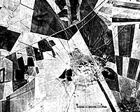
Chicago - Feb 17, 2003 Archaeologists at the University of Chicago's Oriental Institute have used recently declassified satellite surveillance images to show that subtle land depressions -- which had gone largely unnoticed by scholars -- are actually the remnants of ancient roadways that knitted together the fabric of emerging civilizations in the ancient Near East. These 5,000-year-old roadways were important thoroughfares for agricultural exchange and other commerce in an area of Syria and Iraq. It was here that expanding local settlements were coming into contact with cultures from southern Mesopotamia as urban civilization developed in the third millennium B.C., according to Tony Wilkinson, Research Associate at the institute, and Jason Ur, a researcher at the institute. The ancient roads went out of service when better routes emerged late in the first millennium B.C. Because the old roads were in slight depressions, they became locations where local people gathered moist clay for mud bricks. Over the years, the roadways faded and they largely escaped the attention of archaeologists. Although research by the Oriental Institute team focuses on the northern reaches of Mesopotamia, the roads probably were common throughout the region, the scholars said. The roadways were 200 to 400 feet wide and 20 to 24 inches deep. They were made by early people who herded their livestock to fields for pasture and between towns as part of the emerging economic system. Continual traffic by people, animals and vehicles hardened the surface and caused the roadway to sink into the landscape. These inter-site routes are more than connections between towns and nearby settlements, the scholars said. "When considered at a regional level, these routes emerge as segments of larger 'highways' that run from site to site on a generally east-west axis," wrote Ur in his paper, "CORONA Satellite Photography and Ancient Road Networks: A Northern Mesopotamian Case Study," to be published in the spring issue of the journal Antiquity. Previously, archaeologists had drawn straight lines between major settlements, supposing a road system connected them, but not knowing its exact location. Now, rather than connecting the dots in an abstract way, they are able to see where the roads were and how they meandered between settlements. The information also shows that the most important towns were those with the most roadways leading to them. The recent Oriental Institute work in northeastern Syria is based on two sites, Tell Brak and Tell Hamoukar, both of which emerge as communities of some importance in the third millennium B.C. The satellite images show that Tell Hamoukar�the site of a continuing Oriental Institute expedition -- was a more important site than scholars had previously thought. Wilkinson and Ur agree it probably was on a road system that stretched from Nineveh, in what is now northern Iraq, to possibly Aleppo in western Syria near the Mediterranean. "For the Early Bronze Age, new conclusions can be drawn about the underlying economy, which had a large role in producing this pattern of settlements and roads," Ur said. "The agricultural backbone of these towns is vividly illustrated by the abundant radial system of roads, although the interconnectedness of these systems suggests a far more integrated agricultural economy than originally recognized." High-value luxury goods, such as textiles and metals, also traveled on these routes. Now with a better picture of how communities were connected, scholars will be able to further document trade using ancient texts. Community Email This Article Comment On This Article Related Links University of Chicago SpaceDaily Search SpaceDaily Subscribe To SpaceDaily Express Earth Observation News - Suppiliers, Technology and Application
 New York NY (SPX) Jan 11, 2006
The importance of remotely sensed data and technologies to support natural disasters has prompted attention and action in Washington. New initiatives and legislation authorizing appropriations to the remote sensing industry will be discussed at Strategic Research Institute's U.S. Commercial Remote Sensing Industry conference, scheduled for February 9-10, 2006 in Washington D.C. |
|
| The content herein, unless otherwise known to be public domain, are Copyright 1995-2006 - SpaceDaily.AFP and UPI Wire Stories are copyright Agence France-Presse and United Press International. ESA PortalReports are copyright European Space Agency. All NASA sourced material is public domain. Additionalcopyrights may apply in whole or part to other bona fide parties. Advertising does not imply endorsement,agreement or approval of any opinions, statements or information provided by SpaceDaily on any Web page published or hosted by SpaceDaily. Privacy Statement |