|
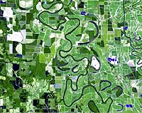
Longmont - May 29, 2003 DigitalGlobe announced that Bowles Farming, an agriculture customer in Los Banos, Calif., is using 30 foot resolution SPOT satellite imagery for precision farming applications, land acquisition assessment, and improved crop quality, asset and nutrition management. In addition to providing the imagery, DigitalGlobe worked closely with Bowles Farming to train company representatives on the use and interpretation of digital satellite imagery. Bowles Farming is a 12,000-acre family farm producing cotton, alfalfa and small grains crops. In April 2002, Cannon Michael, business operations manager for the farm, noticed that 45 acres within a 141-acre field of cotton were producing poor yields due to leakage from an irrigation canal that was causing salt build-up in the soil. The initial proposed solution was to install tile along the entire length of the canal to provide adequate drainage and divert excess water. This solution would cost $127,000 for the purchase of 9,700 feet of tile and two pumps. After examining DigitalGlobe's AgroWatch maps produced from SPOT imagery captured in August 2002, Cannon determined the size of the total affected area was less than half of what he initially anticipated -- 4,250 feet rather than 9,700 feet. Once the actual extent of the drainage problem was identified through satellite imagery, Cannon determined that he required only 4,250 feet of tile and one pump, saving the farm $69,000 on materials alone. The anticipated revenue increase on the yield is expected to be $17,150 after the first year. "Satellite imagery saved our farm thousands of dollars," explained Cannon. "The AgroWatch Green Vegetation maps were key to identifying specific problem areas and are part of our strategy for increasing yields, allowing us to make better long-term farming decisions. "Agriculture is moving into the space age, and that means new ways to accurately and effectively solve old problems. DigitalGlobe makes it very easy for the agriculture market to access and benefit from this complex technology." DigitalGlobe is committed to providing a regularly scheduled and ready-to- use imagery solution to growers, consultants and allied industries in production agriculture. DigitalGlobe's two, eight and 10-foot resolution image products provide the facts for customers to make quicker and better management decisions while reducing economic risk. Bowles Farming views precision agriculture and other new technologies as a way to achieve production goals while maintaining a commitment to providing high-quality crops at lower production costs. In addition to identifying trouble areas, the company is using AgroWatch maps to optimize the number of acres farmed. The short-term use of these information products includes understanding field variations, identifying opportunities and implementing remediation where possible. In the long-term, Bowles Farming will use the imagery to improve crop quality, nutrition and asset management, as well as assess land acquisitions. "To directly and positively affect a business' bottom line is a great success," said John Ahlrichs, director of Agriculture Markets for DigitalGlobe. "We have already started our image collection program for the 2003 growing season and are helping consultants and their growers make in- season crop production decisions. DigitalGlobe is pleased to be part of Bowles Farming's solution and to help them realize all the possibilities of image-based information products for improving their production system." AgroWatch products are produced from satellite imagery by DigitalGlobe to meet information needs of the agricultural community. The AgroWatch Green Vegetation Index aids growers and consultants in making quicker and quantitative scouting and land management decisions. ScoutAide shows the absolute amount of vegetation change and is most valuable for identifying problem areas where the crop is changing faster than expected or validating the result of changing production practices. The AgroWatch Soil Zone map provides users insight into the influence of surface soil characteristics on vegetation health. Combined, these maps are critical for improving production practices over time. DigitalGlobe has exclusive rights to sell SPOT satellite imagery products and services to customers in the U.S. agriculture and defense markets. SPOT products are used by government and commercial clients in the agriculture market to provide very rapid and current information on crop conditions both locally and worldwide for market forecasting, disaster response and long-term planning. Bowles Farming Company Inc. has been in operation since 1965. It was originally part of the Miller and Lux Farming Company. Bowles Farming Company Inc. is a family owned corporation that owns and leases ground (around 12,000 acres total) for the farming of cotton, alfalfa and small grains. Bowles Farming is committed to being low cost producers of high quality crops and views Precision Agriculture as a way to achieve our production goals. Community Email This Article Comment On This Article Related Links DigitalGlobe SPOT Image SpaceDaily Search SpaceDaily Subscribe To SpaceDaily Express Earth Observation News - Suppiliers, Technology and Application
 New York NY (SPX) Jan 11, 2006
The importance of remotely sensed data and technologies to support natural disasters has prompted attention and action in Washington. New initiatives and legislation authorizing appropriations to the remote sensing industry will be discussed at Strategic Research Institute's U.S. Commercial Remote Sensing Industry conference, scheduled for February 9-10, 2006 in Washington D.C. |
|
| The content herein, unless otherwise known to be public domain, are Copyright 1995-2006 - SpaceDaily.AFP and UPI Wire Stories are copyright Agence France-Presse and United Press International. ESA PortalReports are copyright European Space Agency. All NASA sourced material is public domain. Additionalcopyrights may apply in whole or part to other bona fide parties. Advertising does not imply endorsement,agreement or approval of any opinions, statements or information provided by SpaceDaily on any Web page published or hosted by SpaceDaily. Privacy Statement |