|
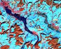
Paris, France (SPX) Mar 21, 2006 A satellite-based rapid mapping service developed to support civil defence activities in eastern France is ready and on call 24 hours a day, seven days a week. The pioneering service has been designed to manage flood events � the world's most widespread category of natural disaster. As well as being applied to risk assessment and prevention efforts, the ESA-backed Flood Plain Monitoring Service aims to deliver map products to end users within six hours during times of crisis, giving emergency responders the ability to track the full extent of floods as they occur. Developed over three years through the ESA Earth Observation Market Development (EOMD) programme, the service was consolidated with the France's Eastern Defence Zone (EDZ), which is made up of 18 departments with a total area of 105 000 sq. km and a population of 8.3 million people. It also includes four major hydrological basins potentially vulnerable to flooding. The service provider is Strasbourg�based rapid mapping specialist firm SERTIT, with the EDZ Prefecture as partner end-user. "We are one of France's seven national civil defence zones," explained Colonel Fran�ois Maurer on behalf of the French Directorate of Civil Defence and Security (DDSC), Chief of Staff (Chef d'�tat-major) of the EDZ. "Our role is to carry out emergency planning, and, in the event of an incident, coordinate the response activities of the various departments. Department prefects are the main decision makers who activate the emergency services but may not have specialist knowledge in the field, so we advise them as needed." The service is based on two types of satellite data. High-resolution imagery from optical satellites is combined with satellite radar imagery which can be acquired even at night or through heavy cloud or rainfall. The large amount of detail found in optical images is used in advance to create reference land cover maps that can be combined when needed with radar images that are highly sensitive to waterlogged surfaces. These images can also be utilised in conjunction with digital elevation models (DEMs) derived from radar data to help model which areas are most at risk.
Combined optical and radar satellite view "We don't mind which satellites are used, we just want the maps," said Colonel Maurer. "Our key issue is time � but very quickly the satellite maps give us an impression of the flood extent, and the areas that are affected. The maps can support high-level decision making and the best use possible of human and material resources. "We can interpret them to see the extent to which the water is going to extend, to help steer our teams around and figure out where best to deploy our pumps and sandbags, where to evacuate first. New buildings may not have made it yet onto standard paper maps, but might still need priority evacuation: hospitals, for example, or homes for the elderly. It is better to perform something like that well in advance rather than when feet are already in the water!" The service was initially designed for flood crisis mapping, but it was soon realised the products would also be relevant for other flood management phases: the post-crisis clean up, prevention and forecasting. Some 80 agencies involved in flood management within the EDZ � such as regional water agencies and flood forecast services � have therefore been briefed on utilising the service. During the last decade floods have affected approximately 1.5 billion people � more than 75% of the total number of people reported as affected as natural disasters worldwide. They are catastrophic events affecting large areas at once, which can make them difficult to predict and monitor. Traditional flood forecasting is carried out using river height and rainfall measurements � often only sparsely available - assimilated into hydrological models. Flood extent is often calculated through historical analysis of maps of past events, or model calculations. �Real-time' flood measurements, if made at all, are carried out through expensive and weather-dependent aerial photography campaigns. Post-crisis damage mapping traditionally relies on ground surveys, projections from population statistics and insurance damage claims. "One of the objectives is to keep detailed satellite-derived maps of past flood events and their evolution, to build an accurate memory of what has happened across our area of interest," added Colonel Maurer. The Flood Plain Monitoring Service has yet to be used in a flood situation within the EDZ, although satellite images are regularly acquired for reference mapping and risk analysis. SERTIT has carried out crisis mapping for a number of flood situations further afield, in locations from Germany to China, often in support of the International Charter on Space and Major Disasters, which prioritises the acquisition of satellite imagery for disaster relief operations. "The use of satellite imagery has recently been added to the operational Civil Protection procedures," concluded Colonel Maurer. "This integration represents a big achievement for the three years of our activity, and shows how the demand for this type of data is here to stay." This achievement has led to the rapid mapping service continuing its development within the framework of ESA's Earthwatch GMES Services Elements (GSE), Risk-EOS and Respond, responding to natural disasters and humanitarian aid situations worldwide providing services to the humanitarian aid community to civil defence agencies. This activity has been carried out as part of a Flood Plain Monitoring project within ESA's EOMD Programme, aimed at strengthening European and Canadian capacities for the provision of geo-information services based mainly on Earth Observation data. Community Email This Article Comment On This Article Related Links ESA Earth Observation Market Development Earth Observation News - Suppiliers, Technology and Application
 Newark DE (SPX) Mar 21, 2006
Move over, Superman, with your X-ray vision. Marine scientists have now figured out a way to "see through" the ocean's surface and detect what's below, with the help of satellites in space. |
|
| The content herein, unless otherwise known to be public domain, are Copyright 1995-2006 - SpaceDaily.AFP and UPI Wire Stories are copyright Agence France-Presse and United Press International. ESA PortalReports are copyright European Space Agency. All NASA sourced material is public domain. Additionalcopyrights may apply in whole or part to other bona fide parties. Advertising does not imply endorsement,agreement or approval of any opinions, statements or information provided by SpaceDaily on any Web page published or hosted by SpaceDaily. Privacy Statement |