|
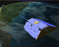
Columbus OH (SPX) Aug 04, 2006 For the first time, scientists have been able to use satellite data to detect the changes in Earth's surface caused by a massive earthquake. The discovery, reported in Friday's issue of the journal Science, signifies a new use for the data from NASA's two GRACE satellites and offers a possible new approach to understanding how earthquakes work. The research paints a clearer picture of how Earth changed after the December, 2004 Sumatra-Andaman earthquake, the 9.1-magnitude temblor in the Indian Ocean, which caused a deadly tsunami killing nearly 230,000 people and displacing more than 1-million. Centered off the west coast of northern Sumatra, the event followed the slipping of two continental plates along a massive fault under the sea floor. The slippage occurred along 750 miles of the line where the Indian plate slides under the Burma plate, a process called subduction. The quake raised the seafloor in the region by several meters for thousands of square miles. "The earthquake changed the gravity in that part of the world in two ways that we were able to detect," explained Shin-Chan Han, a research scientist in the School of Earth Sciences at Ohio State University. First, he said, the quake triggered the massive uplift of the seafloor, changing the geometry of the region and altering previous GPS (global positioning satellite) measurements from the area. Those changes were detectable by GRACE's instruments. Second, the density of the rock beneath the seafloor was changed after the slippage, and an increase or decrease in density produces a detectable gravity change, Han said. The GRACE - for Gravity Recovery and Climate Experiment - satellites were launched in 2002 and have been gathering global gravity measurements ever since. The identical instruments orbit some 186 to 310 miles (300 to 500 kilometers) above the planet's surface and fly 136 miles (220 kilometers) apart. The twin satellites can detect changes in the density of the earth's crust, or in GPS measurements on the ground, which can signal changes in the planet's gravity at that point. Along with OSU colleagues C.K. Shum and Michael Bevis, Han assembled several years of data covering the Indian Ocean region and filtered out seasonal variations. The changing flow of the massive Mekong River, for example, affects gravity measurements for the area and these annual shifts must be removed from the data to detect changes caused by a quake. The researchers then plugged the data into the latest seismic computer model which painted a picture of gravity increases on one side of the fault line and decreases on the other. "With this seismic model we were able to explain and interpret the GRACE observations," Han said, adding that earthquake models are still evolving. "But the observations can also be used to validate the quality of the model itself and therefore improve our knowledge about the solid earth's dynamics." The detection of such quakes comes only after extensive data analysis. Real-time detection is far off in the future - if possible at all. Currently, this GRACE technique was applied to understand the mechanism of great earthquakes - those exceeding magnitude 9.0 on the Richter scale - which are very rare events. NASA is planning to extend the GRACE mission to attempt to detect the effects of major quakes - those measuring from magnitude 7.0 to magnitude 8.9 - which occur more frequently. Community Email This Article Comment On This Article Related Links GRACE Making money out of watching earth from space today Earth Observation News - Suppiliers, Technology and Application
 Bonn, Germany (UPI) Aug 01, 2006
The world's scientists are increasingly using Google Earth's digital globe, which has also attracted millions of non-scientists around the world. |
|
| The content herein, unless otherwise known to be public domain, are Copyright 1995-2006 - SpaceDaily.AFP and UPI Wire Stories are copyright Agence France-Presse and United Press International. ESA PortalReports are copyright European Space Agency. All NASA sourced material is public domain. Additionalcopyrights may apply in whole or part to other bona fide parties. Advertising does not imply endorsement,agreement or approval of any opinions, statements or information provided by SpaceDaily on any Web page published or hosted by SpaceDaily. Privacy Statement |