|
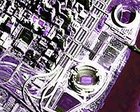
Athens, Ohio - Sep 17, 2002 Orbiting 500 miles above the planet, satellites give scientists a "big picture" view of changes to the Earth's landscape -- from suburbanization trends to shoreline erosion. Now, an Ohio University researcher is using the technology to try to detect a more dangerous activity: terrorism and the areas of the country most vulnerable to potential attacks. With the aid of a grant from NASA, geographer James Lein will study the use of satellite data to identify geographic areas that could be at risk of terrorist threats. The project, aimed at supporting homeland security, will use information collected from the Landsat and Aster satellites to inventory chemical and power plants, utility lines, key public buildings and geographic characteristics of a region, including population density. Changes in the data, updated every 24 hours, could identify problems and emergencies. "Satellite data has the advantage of being able to see a lot of different things in a lot of different ways," said Lein, an associate professor of geography at Ohio University. "The project is trying to support the idea of homeland security by giving information to communities that haven't thought about what's in their backyards." The satellites, supported by NASA and the U.S. Geological Survey, can use digital cameras to zoom in on geographic areas as small as a half meter in size to capture finely detailed images of the landscape, Lein said. For several years, researchers have used satellites to track changes in the Earth's landscape to monitor such issues as the loss of farm land to residential development, deforestation and water pollution. For the purposes of homeland security, government officials can compare images from the same location over time to detect unusual activity, such as at the site of a remote pipeline. "It could signal to policy makers where they might be vulnerable and where they should take appropriate actions," he said. The satellites collect information in a process known as "remote sensing," or measuring energy wavelengths such as sunlight reflected off the surface of the Earth. Different land surfaces, such as forests, streams, agricultural fields, reflect different energy patterns. The satellites then transmit the information, often in electronic form, to a ground station where the data are processed into an image. The technology also could have potential for the detection of airborne agents, Lein noted. Highly sensitive satellites can spot the wavelength signatures of gases in the atmosphere, as they can record between 100 to 250 different types of energy wavelengths, compared with other satellites, which pick up between only three and 12 types. The number of chemical industries and power plants located on the Ohio River makes southeastern Ohio a good test site for the project, Lein said. Preliminary work suggests that the technology could be applied to other areas of the country as well, he added. Lein intends to make the satellite data available to state and local government officials as a resource for security planning and response programs. Lein previously used satellite technology and remote sensing for risk assessment of natural hazards, including identifying homes in the flood plain that could be damaged by floods. The homeland security project, an idea spawned from a discussion with an Ohio policy maker, is a natural outgrowth of the prior work, he said. His 18-month NASA grant for the project is administered through the Ohio Aerospace Institute. The geographer is a member of Ohio View, a consortium of 10 Ohio universities and government partners dedicated to using satellite data for education and research purposes. Recent projects by the organization's researchers include using the data to study gypsy moth infestations around the state and water quality of Lake Erie. Lein expects to compile more findings from the homeland security project, which will involve Ohio University graduate students, in four to five months and will present and publish data in the upcoming year. Community Email This Article Comment On This Article Related Links Ohio University SpaceDaily Search SpaceDaily Subscribe To SpaceDaily Express The Long War - Doctrine and Application
 Oak Ridge TN (SPX) Jun 17, 2004
Thousands of special agents created at the Department of Energy's Oak Ridge National Laboratory are on missions 24 hours a day as they work to uncover threats to national security. These agents, which are actually intelligent software programs, scan the Internet, satellite images, hundreds of newspapers and electronic databases worldwide as they search for anything that even hints at a plot. |
|
| The content herein, unless otherwise known to be public domain, are Copyright 1995-2006 - SpaceDaily.AFP and UPI Wire Stories are copyright Agence France-Presse and United Press International. ESA PortalReports are copyright European Space Agency. All NASA sourced material is public domain. Additionalcopyrights may apply in whole or part to other bona fide parties. Advertising does not imply endorsement,agreement or approval of any opinions, statements or information provided by SpaceDaily on any Web page published or hosted by SpaceDaily. Privacy Statement |