|
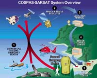
Washington - Nov 25, 2003 On land and in the sea satellites helped save lives the past week. In one incident, two passengers onboard a sailing vessel from Harpswell, Maine, headed for the Caribbean Island of Antigua, made it only as far as Nantucket, Mass., because of rough sea conditions spawned by violent weather. (Click NOAA image for larger view of Cospas-Sarsat system overview.) Their boat, the Moonlight Contessa, capsized last Friday in the open waters of the Atlantic, but a small fleet of U.S. Coast Guard aircraft and rescue personnel pulled the victims to safety. The incident was part of a busy Nov. 14 for the Search and Rescue Satellite Aided Tracking System, better known as SARSAT. On the same day, a Cleveland man, camping in the remote Adirondack Mountains of Upstate New York, used a personal locator beacon (PLB) to trigger a rescue by the U.S. Air Force Rescue Coordination Center (AFRCC) after experiencing several days worth of heavy snows that had trapped him in his campsite. The AFRCC dispatched the U.S. Army's Fort Drum Air Ambulance Detachment to the scene of the distress. It was the first such rescue in the contiguous United States using a PLB, since the program went operational in July. "The SARSAT system is doing exactly what it should -- saving the lives of people in distress," said Gregory W. Withee, assistant administrator for the NOAA Satellites and Information Service. SARSAT is a team effort between NOAA, which oversees the system's operations, and the Air Force and Coast Guard, which provide the rescue coordination and response. The SARSAT system uses NOAA's polar-orbiting and geostationary-orbiting satellites to detect and locate registered owners of PLBs, Emergency Position Indicating Radio Beacon (EPIRBs), or Emergency Locator Transmitters (ELTs), who are in distress. Hikers and campers use PLBs, which are designed for land use, EPIRBS are used on board boats and ships, while ELTs are carried aboard aircraft. Once the satellites pick up a distress signal, it is relayed to U.S. Mission Control Center at the NOAA Satellites and Information facility in Suitland, Md. After pinpointing the location of the distress, the signal is routed to a Rescue Coordination Center operated by the Coast Guard or the Air Force. In the United States, the Coast Guard has responsibility for all maritime distresses, and the Air Force handles all inland search and rescue cases. In the Moonlight Contessa rescue, the Coast Guard's District One RCC in Boston dispatched a C-130 plane and two helicopters to the trouble spot in the area southeast of Nantucket. In the heavy seas, the sailboat had rolled over, was dismasted and suffered subsequent electrical and engine failures. "These two passengers were clearly in a life or death situation," said Lieutenant Commander Jay Dell, with the Coast Guard's Office of Search and Rescue headquarters in Washington, D.C. "Their boat was being torn apart by the seas, but their EPIRB was able to transmit the distress signal to NOAA. Once NOAA passed the alert onto our District One RCC, they quickly dispatched the rescue personnel and helicopters and made the saves." Lieutenant Daniel Karlson, SARSAT operations support officer for NOAA, added, "SARSAT worked, and these two lives were saved because the boat had a beacon. Without it, we would have had a real tragedy." NOAA is dedicated to enhancing economic security and national safety through the prediction and research of weather and climate-related events and providing environmental stewardship of the nation's coastal and marine resources. NOAA is part of the U.S. Department of Commerce. Community Email This Article Comment On This Article Related Links Cospas-Sarsat at NOAA International Cospas-Sarsat Program SpaceDaily Search SpaceDaily Subscribe To SpaceDaily Express Dirt, rocks and all the stuff we stand on firmly
 Paris (ESA) Jan 12, 2006
Using the ESA Cluster spacecraft and the NASA Wind and ACE satellites, a team of American and European scientists have discovered the largest jets of particles created between the Earth and the Sun by magnetic reconnection. This result makes the cover of this week's issue of Nature. |
|
| The content herein, unless otherwise known to be public domain, are Copyright 1995-2006 - SpaceDaily.AFP and UPI Wire Stories are copyright Agence France-Presse and United Press International. ESA PortalReports are copyright European Space Agency. All NASA sourced material is public domain. Additionalcopyrights may apply in whole or part to other bona fide parties. Advertising does not imply endorsement,agreement or approval of any opinions, statements or information provided by SpaceDaily on any Web page published or hosted by SpaceDaily. Privacy Statement |