|
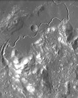
Paris (ESA) Sep 01, 2005 This image, taken by the Advanced Moon Micro-Imager Experiment (AMIE) on board ESA's SMART-1 spacecraft, shows the Hadley Rille on the south-east edge of Mare Imbrium on the Moon. AMIE obtained this image from an altitude of about 2000 kilometres. It covers an area of about 100 kilometres and shows the region around Hadley Rille centred at approximately 25� North and 3� East. The sinuous rille follows a course generally to the north-east toward the peak of Mount Hadley, after which it is named (bright feature, top right). To the east of this rille, south-west of Mount Hadley, is Mount Hadley Delta, one of the largest Appenine mountains. The Appenine mountains mark the edge of the impact basin holding Mare Imbrium, rising between 1800 and 4500 metres above the mare. They are the bright bumps in the lower half of the image. The valley between these two peaks is fairly well known because NASA astronauts David R. Scott and James B. Irwin landed there during the Apollo 15 mission in 1971. The landing site is near the upper right part of the rille (26.1� North and 3.9� East) on a dark mare plain called Palus Putredinis (Marsh of Decay). The rille begins at the curved gash on the left side of this image, and is seen clearest in the rectangular, mare-floored valley in the centre of the image. It is over 120 kilometres long, and up to 1500 metres across and over 300 metres deep in places. The rille formed nearly 3300 million years ago. In contrast, lava channels on Hawaii are usually under 10 kilometres long and are only 50-100 metres wide. The Hadley C crater next to the rille is about 5 kilometres in diameter. Sinuous rilles are probably the most recognisable of small volcanic features on the Moon. Many partially resemble river valleys on Earth. However, the lunar rilles usually flow away from small pit structures. The rilles mark lava channels or collapsed lava tubes that formed during mare volcanism. Indeed, the lunar samples indicate that the Moon has always been dry, thus confirming the volcanic origin of the rilles. Still, in some cases, the lunar flows may have melted their way down into older rocks, much like rivers cut into their flood plains on Earth. Similar lava channels and tubes are found in Hawaii, but these are all much, much smaller than those found on the Moon, indication that the very low lunar gravity has a strong influence on morphological processes. Community Email This Article Comment On This Article Related Links SpaceDaily Search SpaceDaily Subscribe To SpaceDaily Express Mars News and Information at MarsDaily.com Lunar Dreams and more
 Paris, France (ESA) Dec 28, 2005
ESA's SMART-1 spacecraft has been surveying the Moon's surface in visible and near-infrared light using a new technique, never before tried in lunar orbit. |
|
| The content herein, unless otherwise known to be public domain, are Copyright 1995-2006 - SpaceDaily.AFP and UPI Wire Stories are copyright Agence France-Presse and United Press International. ESA PortalReports are copyright European Space Agency. All NASA sourced material is public domain. Additionalcopyrights may apply in whole or part to other bona fide parties. Advertising does not imply endorsement,agreement or approval of any opinions, statements or information provided by SpaceDaily on any Web page published or hosted by SpaceDaily. Privacy Statement |