|
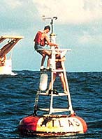
Boulder - Mar 17, 2003 As a result of recent measurement corrections made possible by the National Institute of Standards and Technology (NIST), the Earth's oceans may look a bit bluer than they did before in satellite images--meaning there may be less carbon in the oceans than previously thought. A unique NIST tabletop-sized instrument, called the "traveling SIRCUS" (a miniature version of the agency's Spectral Irradiance and Radiance Calibrations with Uniform Sources facility), was transported to Hawaii last year to calibrate the Marine Optical Buoy systems (known as MOBY) that measure the color and magnitude of light reflected from and within the ocean. Data from these systems are used to calibrate satellite-borne color mapping instruments. Ocean color is important in climate research because variations in the visible light spectrum reflect the concentration of microscopic marine plants, which utilize carbon dioxide from the ocean/atmosphere system for photosynthesis. These phytoplankton absorb blue light and reflect predominantly green light, whereas water reflects predominantly blue. The satellite observations are used to produce global assays of biomass and carbon production in the world's oceans. The laser-based traveling SIRCUS helped correct errors in the buoy's measurements. The corrections are having an impact on scientists' calculations of the biomass and carbon concentrations present in the oceans, which will provide a more accurate understanding of Earth's carbon balance and its effect on climate. Community Email This Article Comment On This Article Related Links National Institute of Standards and Technology SpaceDaily Search SpaceDaily Subscribe To SpaceDaily Express Earth Observation News - Suppiliers, Technology and Application
 New York NY (SPX) Jan 11, 2006
The importance of remotely sensed data and technologies to support natural disasters has prompted attention and action in Washington. New initiatives and legislation authorizing appropriations to the remote sensing industry will be discussed at Strategic Research Institute's U.S. Commercial Remote Sensing Industry conference, scheduled for February 9-10, 2006 in Washington D.C. |
|
| The content herein, unless otherwise known to be public domain, are Copyright 1995-2006 - SpaceDaily.AFP and UPI Wire Stories are copyright Agence France-Presse and United Press International. ESA PortalReports are copyright European Space Agency. All NASA sourced material is public domain. Additionalcopyrights may apply in whole or part to other bona fide parties. Advertising does not imply endorsement,agreement or approval of any opinions, statements or information provided by SpaceDaily on any Web page published or hosted by SpaceDaily. Privacy Statement |