|
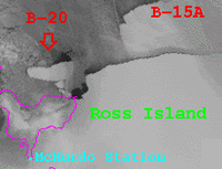
Suitland - October 8, 2000 A new iceberg, 345 square miles in area, has splintered away from Antarctic's Ross Ice Shelf in the Ross Sea, the National Ice Center in Suitland, Md., reports. Iceberg B-20 was detected on September 27 using the Defense Meteorological Satellite Program's Optical Linescan Sensor infrared imagery. It is known to have broken away from the Ross Ice Shelf sometime between September 20 and 26. The exact date of splintering is currently unknown due to the extensive cloud cover that persisted over the southern Ross Sea. B-20 is located in the vicinity of Latitude 77 degrees, 00 minutes south; Longitude 170 degrees, 42 minutes east, and has moved northwest since breaking away from the Ross Ice Shelf. B-20 measures 30 by 11.5 statute miles. Iceberg names are derived from the Antarctic quadrant in which they were originally sighted. The quadrants are divided counter-clockwise in the following manner:
A = 0 to 90 degrees West longitude (Bellinghausen/Weddell Sea) When an iceberg is first sighted, the National Ice Center documents its point of origin. The letter of the quadrant, along with a sequential number, is assigned to the iceberg. For example, B-20 is the 20th iceberg the ice center has found in Antarctica in Quadrant B since it began monitoring in 1976. The National Ice Center, a tri-agency operational activity with representation from the U.S. Navy, NOAA, and the U.S. Coast Guard, provides worldwide operational sea ice analyses and forecasts tailored to meet the requirements of U.S. national interests. The center tracks icebergs using remotely sensed data provided in-part by satellites operated by NOAA and the Department of Defense. Relevant Web Sites * An image of B-20 is available on the National Ice Center Web site http://www.natice.noaa.gov/pub-info/Icebergs/B20.gif * Defense Meteorological Satellite Program http://www.natice.noaa.gov/pub-info/Icebergs/B20.gif * Archived Satellite Images, Storm Animations and Special Events, Including Icebergs http://www5.ncdc.noaa.gov/cgi-bin/hsei/hsei.pl?directive=welcome CommunityEmail This Article Comment On This Article Related Links SpaceDaily Search SpaceDaily Subscribe To SpaceDaily Express Dirt, rocks and all the stuff we stand on firmly
 Paris (ESA) Jan 12, 2006
Using the ESA Cluster spacecraft and the NASA Wind and ACE satellites, a team of American and European scientists have discovered the largest jets of particles created between the Earth and the Sun by magnetic reconnection. This result makes the cover of this week's issue of Nature. |
|
|
|
|
|
|
|
|
|
|
|
|
|
| The content herein, unless otherwise known to be public domain, are Copyright 1995-2006 - SpaceDaily.AFP and UPI Wire Stories are copyright Agence France-Presse and United Press International. ESA PortalReports are copyright European Space Agency. All NASA sourced material is public domain. Additionalcopyrights may apply in whole or part to other bona fide parties. Advertising does not imply endorsement,agreement or approval of any opinions, statements or information provided by SpaceDaily on any Web page published or hosted by SpaceDaily. Privacy Statement |