 |
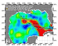
Pasadena CA (JPL) Sep 23, 2005 This sea surface height map of the Gulf of Mexico, with the Florida peninsula on the right and the Texas-Mexico Gulf Coast on the left, is based on altimeter data from four satellites including NASA's Topex/Poseidon and Jason. Red indicates a strong circulation of much warmer waters, which can feed energy to a hurricane. This area stands 35 to 60 centimeters (about 13 to 23 inches) higher than the surrounding waters of the Gulf. The actual track of a hurricane is primarily dependent upon steering winds, which are forecasted through the use of atmospheric models. However, the interaction of the hurricane with the upper ocean is the primary source of energy for the storm. Hurricane intensity is therefore greatly affected by the upper ocean temperature structure and can exhibit explosive growth over warm ocean currents and eddies. Eddies are currents of water that run contrary to the direction of the main current. According to the forecasted track through the Gulf of Mexico, Hurricane Rita will continue crossing the warm waters of a Gulf of Mexico circulation feature called the Loop Current and then pass near a warm-water eddy called the Eddy Vortex, located in the north central Gulf, south of Louisiana. The Jason satellite carries a dual-frequency radar altimeter. This instrument beams microwave pulses-at 13.6 and 5.3 Gigahertz, respectively-downward toward the Earth. To determine the ocean's height, the instrument precisely measures the time it takes for the microwave pulses to bounce off the surface and return to the spacecraft. This measure, multiplied by the speed of light, gives the range from the satellite to the ocean surface. Community Email This Article Comment On This Article Related Links Topex/Poseidon information SpaceDaily Search SpaceDaily Subscribe To SpaceDaily Express Bringing Order To A World Of Disasters When the Earth Quakes A world of storm and tempest
 New Orleans, Louisiana (AFP) Jan 05, 2006
Thousands of students and faculty are returning to New Orleans' eight colleges and universities this week for the first time since hurricane Katrina flooded the city four months ago. |
|
| The content herein, unless otherwise known to be public domain, are Copyright 1995-2006 - SpaceDaily.AFP and UPI Wire Stories are copyright Agence France-Presse and United Press International. ESA PortalReports are copyright European Space Agency. All NASA sourced material is public domain. Additionalcopyrights may apply in whole or part to other bona fide parties. Advertising does not imply endorsement,agreement or approval of any opinions, statements or information provided by SpaceDaily on any Web page published or hosted by SpaceDaily. Privacy Statement |
