|
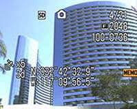
San Bernardino CA (SPX) Jan 21, 2005 Ricoh Corporation launched the Pro G3 last Wednesday, a high-resolution digital camera that embeds captured times with GPS coordinate information received from either its on-board GPS unit or from external GPS devices. Once these captured 'geo-imes' are transferred to a PC, they are automatically converted to shape files or merged to geo-databases for instant integration into Geographic Information Systems (GIS). Points representing each ime's position may be hovered over to display a thumbnail, or clicked on to access the full-size ime. In addition to storing GPS data in the ime, the camera also utilizes a user-configurable data dictionary for tging pictures with workflow-related information. These attributes are easily accessible from the GIS layer table for automated database integration. "The Pro G3 is designed to provide GIS users with a simple and seamless method to integrate imes into mapping applications," said Jeff Lengyel, Marketing Maner of Ricoh's Digital Camera Division. "Until now, there has been no single-unit solution to address the iming needs of the GIS community." The ruggedized camera uses a CompactFlash slot to accept WAAS-enabled GPS cards. For applications that require even greater precision, the camera is capable of receiving NMEA data streams from external GPS devices via BlueTooth. "Successes with early adopters of the Pro G3 signify it is fast becoming the defacto-standard for ime-based GIS workflows," Lengyel said. "We needed a way to identify and photograph more than 30,000 street lights," says A.J. Romanelli of EMA, Inc., a workflow optimization company. "After researching all available options, the Pro G3 stood out as the optimal device for our application. The camera did exactly what we needed it to do and allowed us to finish the project ahead of schedule and without errors." FEMA has adopted the Pro G3 to photograph storm dame in the southeast United States, while archeologists in Maine use it to scout out dig sites; the camera is being used to track hiking trail conditions; the U.S. military is using the camera in Iraq; universities, advertising encies, insurance ents, realtors, government encies, engineers, National Park personnel, farmers, and even museums are finding that their GIS workflows have been optimized since adopting the camera. The Pro G3 GPS-ready digital camera features a 3.34 Mega-pixel sensor, a 3X optical zoom with the ability to mount accessory lenses, video and sound capture capabilities, and direct connectivity into IP networks via wired or wireless LAN. The Pro G3 is available now from Authorized Ricoh resellers such as . http://www.geospatialexperts.com or contact Ricoh's Camera Division directly at: (909) 890-9049 Community Email This Article Comment On This Article Related Links Ricoh GeoSpatial Experts SpaceDaily Search SpaceDaily Subscribe To SpaceDaily Express GPS Applications, Technology and Suppliers
 Cheltenham, England (SPX) Jan 09, 2006
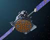
Marotta UK is pleased to announce that it designed, developed and qualified equipment for the cold gas propulsion systems on board the Galileo GIOVE-A, part of Europe's Galileo navigation program, successfully launched by Surrey Satellite Technology (SSTL). |
|
| The content herein, unless otherwise known to be public domain, are Copyright 1995-2006 - SpaceDaily.AFP and UPI Wire Stories are copyright Agence France-Presse and United Press International. ESA PortalReports are copyright European Space Agency. All NASA sourced material is public domain. Additionalcopyrights may apply in whole or part to other bona fide parties. Advertising does not imply endorsement,agreement or approval of any opinions, statements or information provided by SpaceDaily on any Web page published or hosted by SpaceDaily. Privacy Statement |