|
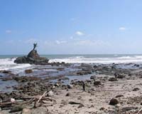
Atlanta GA (SPX) Dec 07, 2006 Analyses of a classic, slow-rupturing tsunami earthquake whose massive waves devastated the coast of Java, Indonesia, this past summer are providing insight to seismologists and engineers, who want to better understand these rare events, recommend strategies to improve safety and perhaps provide long-range forecasts of potential danger zones worldwide. Among the surprises is data indicating that a secondary underwater movement amplified the original tsunami to create a wave run-up more than 60 feet high along more than a one-mile section of coastline. Data also raise the possibility that some regional geophysical characteristic may be making Java more vulnerable to tsunami earthquakes. Researchers from across the globe will present new analyses of seismic data, field survey information and modeling results of the July 17, 2006 tsunami earthquake at the American Geophysical Union's (AGU) fall meeting in San Francisco. Andrew Newman, an assistant professor of geophysics at the Georgia Institute of Technology's School of Earth and Atmospheric Sciences, and Susan Bilek, an assistant professor of geophysics at the New Mexico Institute of Mining and Technology are presiding over the Dec. 11 session devoted to the July disaster. "Sharing what we're learning will help us to better characterize tsunami earthquakes and where they occur," Newman said. "We'll also be able to better assess in the future when these kind of earthquakes occur whether they are likely to create tsunamis." Only about 0.1 percent of earthquakes of a 6.0 or larger magnitude on the Richter scale in the past 40 years have been classified as tsunami earthquakes, but their potentially catastrophic impact demands investigation into why and where they occur, Newman explained. A tsunami earthquake is a slow-rupturing quake that occurs near the ocean floor. It uplifts a piece of the sea floor, and that deformation displaces water that propagates out to create a tsunami. Just 30 feet of slip in tectonic plates can create a 60-foot or higher wave on shore, and local wave run-up can be even higher, Newman noted. Seismic data on the Java event revealed that the earthquake, which measured 7.7 on the Richter scale, did indeed rupture slowly compared to a typical earthquake, Newman said. It created a deadly tsunami that hit a 300-mile stretch of Java's coastline and claimed more than 600 lives in a 125-mile-long, high-impact area. Newman and Bilek analyzed the distribution of aftershocks that occurred in the two weeks following the July 17 event. Most of them occurred at shallow depths and close to the trench - the area where the Australian and Sunda plates collided. "The nature of these aftershocks was a dead giveaway that this event was a classic tsunami earthquake," Newman explained. "Only tsunami earthquakes rupture in the shallowest portion of the trench - only a few kilometers below the sea floor." The July 2006 tsunami earthquake was the second such event to occur on the Java trench in the past 40 years; the previous one happened in 1994. "There may be something going on in this particular trench - some regional characteristic - that is increasing the potential for tsunami earthquakes in this area," Newman noted. His previous study of global data from 1970 to 2000 showed no indication of any seismic characteristics that made tsunami earthquakes occur more frequently in certain regions, but the Java event has renewed his interest in this possibility. In another presentation in the same AGU meeting session, Hermann Fritz, a Georgia Tech assistant professor of civil and environmental engineering, will report the findings of the International Tsunami Survey Team (ITST) that he led into Java about two weeks after the tsunami earthquake. The team gathered perishable data on wave run-up, inundation, damage to structures, and sediment erosion and deposition along a 350-mile stretch of coastline. They recorded numerous eyewitness accounts on video to document survival strategies, as well as wave sequence and periods. Most areas were hit by waves not exceeding 30 feet, but the team documented greater impact to a one-mile-long stretch of coastline on the island of Nusa Kambangan. It is a restricted-access area because high-security prisons are located there. In this area, the tsunami wave size exceeded 60 feet and inundated the coastline for more than half a mile inland, killing 19 inmates. "The violent tsunami impact on Nusa Kambangan was visualized by a sharp trimline carved into the impact zone," Fritz said. "It shredded an entire forest and caused massive beach erosion of more than a meter vertically. The violent impact extended several miles beyond the area of island coastline we visited, but the rest was not accessible. We were the only survey team that was granted access - which was in the company of federal agents -- to the off-limits island. "This was an unusually high wave run-up for an earthquake with a magnitude of 7.7," Fritz explained. "So we presume there was some local forcing, or underwater earth movement, such as a sub-marine landslide or slump, that may have been triggered by the earthquake and caused a larger tsunami to hit this local area." Most of the tsunami's casualties - more than 400 of them - occurred in Java's prime beach-tourist destination of Pagandaran, which is more than 20 miles west of Nusa, Fritz said. As is common with slow-rupturing tsunami earthquakes, most people onshore in Java did not feel any shaking when the quake occurred 125 miles offshore, Fritz noted. "Even the trained lifeguards on the beaches had a hard time recognizing the classic tsunami harbinger of initial shoreline recession," he added. "They didn't notice it because of the large surf waves that day." Though the Pacific Tsunami Warning Center issued a tsunami warning following the earthquake, it did not result in a local warning and evacuation because of communication and other logistical problems, Fritz said. But even if there had been a local warning, people would only have had 10 to 15 minutes at most to evacuate because the earthquake occurred so close to shore, he added. Fritz and the survey team called for better education of the public to help them recognize the precursors of a tsunami. "Even if people feel weak ground-shaking on shore, they should move to higher ground," he said. "There's typically some degree of ocean drawback and/or an initial higher-than-normal wave, though the first wave is rarely the biggest one.... Also, when people evacuate the beach, they need to stay away from the shore for the recommended six hours." Researchers, including Fritz and his survey team colleagues, are working with the United Nations Educational, Scientific and Cultural Organization (UNESCO) to improve public education about tsunamis. Public awareness has improved in Indonesia, Fritz said, but needs a boost in other at-risk areas, including the Pacific Northwest coastline of the United States, Nicaragua, Costa Rica, Puerto Rico and Peru. Community Email This Article Comment On This Article Related Links Georgia Institute of Technology Research News Bringing Order To A World Of Disasters When the Earth Quakes A world of storm and tempest
 Legaspi, Philippines (AFP) Dec 05, 2006
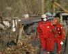
The first foreign aid flights of food and medicines arrived Tuesday in the eastern Philippines, where officials said devastating mudslides had left at least 1,266 people dead or missing. At first light two C-130 transport aircraft from Indonesia touched down in Legaspi city, where disaster relief operations are being coordinated, carrying more than 12 tonnes of food and medicine. |
|
| The content herein, unless otherwise known to be public domain, are Copyright 1995-2006 - SpaceDaily.AFP and UPI Wire Stories are copyright Agence France-Presse and United Press International. ESA PortalReports are copyright European Space Agency. All NASA sourced material is public domain. Additionalcopyrights may apply in whole or part to other bona fide parties. Advertising does not imply endorsement,agreement or approval of any opinions, statements or information provided by SpaceDaily on any Web page published or hosted by SpaceDaily. Privacy Statement |