|
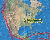
Lexington KY (SPX) Dec 20, 2006 Drilling has been completed on the deepest borehole for seismic instruments in the eastern U.S. The four-inch diameter hole for the Central U.S. Seismic Observatory (CUSSO), located at Sassafras Ridge in Fulton County, Kentucky, reached a depth of 1,948 feet, where bedrock was encountered. The location is near the most active part of the New Madrid Seismic Zone, the source of at least three major earthquakes in the winter of 1811-12, before the region was heavily populated and developed. This location will allow instruments in the seismic hole to gather the maximum amount of data from the region's earthquakes for thorough evaluation of their effects on bedrock and soil and the resulting ground motions. "Now that the well has been completed, our focus will be on getting instruments installed and collecting data vital to the region," says Jim Cobb, director of the Kentucky Geological Survey (KGS) and state geologist The partners in the project, including the University of Kentucky, KGS, and several federal agencies, will now determine the type and number of instruments to place in the shaft and at what depths to place them. Five partners involved in the project committed nearly $300,000 to the drilling project. Much of the funding came from the U.S. Department of Energy through the Kentucky Research Consortium for Energy and Environment. The Department of Energy has an interest in the region's earthquakes due to uranium enrichment operations at the Paducah Gaseous Diffusion Plant. Edward W. Woolery of UK's Department of Earth and Environmental Sciences and Zhenming Wang of KGS led the effort to plan and secure funding for the project. The next step in the process of completing the project will involve a workshop sponsored by the partners to gather input about the instruments to be placed in the observatory. The partners will apply to agencies such as the Department of Energy, the National Science Foundation, and other sources of funding for the purchase and installation of the instruments. When instrumentation is completed, the observatory will be added to the Kentucky Seismic and Strong-motion Network, a series of monitoring stations operated by KGS and the Department of Earth and Environmental Sciences. It will add new data on the origin, location, magnitude, and depth of earthquakes in this region to the information currently gathered by the network's 26 instruments. Data collected will help geologists and engineers better define the earthquake hazard in the region. Knowing the hazard has implications for economic development in the region as well as specific applications for ongoing activities at the Paducah Gaseous Diffusion Plant. Community Email This Article Comment On This Article Related Links University of Kentucky When the Earth Quakes Tectonic Science and News
 Baton Rouge LA. (UPI) Dec 19, 2006
 U.S. geologists say they have determined Louisiana is subsiding vertically and moving southward in respect to North America. |
|
| The content herein, unless otherwise known to be public domain, are Copyright 1995-2006 - SpaceDaily.AFP and UPI Wire Stories are copyright Agence France-Presse and United Press International. ESA PortalReports are copyright European Space Agency. All NASA sourced material is public domain. Additionalcopyrights may apply in whole or part to other bona fide parties. Advertising does not imply endorsement,agreement or approval of any opinions, statements or information provided by SpaceDaily on any Web page published or hosted by SpaceDaily. Privacy Statement |