|
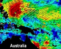
Pasadena - Mar 18, 2002 Wind data for the Pacific Ocean obtained by NASA's Quick Scatterometer spacecraft -- also know as Quikscat -- are documenting episodes of reversed trade winds that are responsible for unseasonable cyclone conditions in the northwest and southwest Pacific, and which may be a precursor of a future El Nino. A research team led by Dr. W. Timothy Liu, a senior research scientist at NASA's Jet Propulsion Laboratory in Pasadena, Calif., used wind speed and direction data from Quikscat to detect a shift in the trade winds on February 25. The winds shifted from their normal easterly direction to a westerly direction, blowing from Indonesia toward the Americas along the equator. This trade wind shift, which lasted for about a week, contributed to the spawning of twin cyclones-- Super Typhoon Mitag, which threatened the Philippines; and Tropical Cyclone Des, which passed through New Caledonia. "In addition to unusual cyclonic activity, such trade wind reversals typically trigger Kelvin waves of warm water, which can be an early indicator of future El Nino conditions," said Liu. "During periods of reversed trade winds, which typically last from a few days to a week or more, equatorial westerly winds generate a counterclockwise vortex in the northern hemisphere and a clockwise vortex in the southern hemisphere. "Once spawned, the resulting Kelvin waves may travel across the Pacific and reach the coastline of the Americas in approximately one to two months, warming the waters of the eastern Pacific and creating El Nino conditions when the effects are accumulated." Sustained Kelvin wave activity could have a major impact on global weather patterns according to JPL oceanographer Dr. William Patzert. "If trade wind patterns continue to experience reversals through the spring and summer, the resulting strong, warm Kelvin waves will cross the Pacific like a conveyor belt, depositing warm water near South America where the ocean is normally cold," he said. "Such a 'warm pool' could alter weather all over the planet, with rains that would normally soak the western Pacific shifting toward the Americas, and places such as Indonesia and India becoming drier. We're really in a 'wait and see' situation at this point." A similar westerly wind flow and twin cyclones were documented by Liu and his team using Quikscat data last December. The wind reversal at that time, which lasted 10 days, triggered a Kelvin wave that just recently reached South America, as revealed by NASA's Topex/Poseidon satellite. Community Email This Article Comment On This Article Related Links More details of the two westerly winds events Topex/Poseidon SpaceDaily Search SpaceDaily Subscribe To SpaceDaily Express Dirt, rocks and all the stuff we stand on firmly
 Bangkok (AFP) Dec 9, 2005
Environmental damage threatens human health and may have contributed to the spread of new diseases like bird flu and SARS, the World Health Organization said in a report Friday. |
|
| The content herein, unless otherwise known to be public domain, are Copyright 1995-2006 - SpaceDaily.AFP and UPI Wire Stories are copyright Agence France-Presse and United Press International. ESA PortalReports are copyright European Space Agency. All NASA sourced material is public domain. Additionalcopyrights may apply in whole or part to other bona fide parties. Advertising does not imply endorsement,agreement or approval of any opinions, statements or information provided by SpaceDaily on any Web page published or hosted by SpaceDaily. Privacy Statement |