|
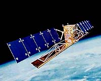
Saint-Hubert - Nov 05, 2003 The Canadian Space Agency (CSA) today celebrated eight productive years in space with Radarsat-1, surpassing all expectations for a mission that was initially planned for five years. This premier Earth Observation satellite, Radarsat-1, has been maintained by the CSA Satellite Operations' team to enhance its ability to deliver accurate and timely images for the Government of Canada and a range of public and private sector clients located in more than sixty countries worldwide. "Radarsat-1 continues to be a key component of the web of Earth Observation satellites," said CSA President Marc Garneau. "Its daily applications are innumerable in such domains as ice monitoring, forestry, cartography and oceanography. The reliability and accuracy of this satellite are extraordinary, helping Canada stand out for the quality and durability of its space hardware and specialized applications." Radarsat-1 has literally mapped the world producing detailed reference maps of Antarctica, Canada, the contiguous United States and Africa and most recently has been used in emergency situations as part of the International Charter on Space and Natural Disasters. In the past year, it most notably provided images of the flooding in British Columbia that caused such extensive damage to the province. Internationally, Radarsat-1 provided images of the Prestige oil spill near Spain's coastline and of the Stromboli volcanic eruption in Italy, demonstrating the range and utility of images produced by the satellite. The launch of Radarsat-1's successor, Radarsat-2, is planned for the end of 2005. The satellite's structure and payload are developing well in the plants of subcontractors to MacDonald Detwiller and Associates (MDA), the project's main contractor. The commercialization of Radarsat-2 satellite data will be managed by MDA subsidiary Radarsat International (RSI), which provides data to some 20 certified ground stations throughout the world distributing images to over 600 clients globally. Community Email This Article Comment On This Article Related Links Canadian Space Agency Radarsat SpaceDaily Search SpaceDaily Subscribe To SpaceDaily Express Earth Observation News - Suppiliers, Technology and Application
 New York NY (SPX) Jan 11, 2006
The importance of remotely sensed data and technologies to support natural disasters has prompted attention and action in Washington. New initiatives and legislation authorizing appropriations to the remote sensing industry will be discussed at Strategic Research Institute's U.S. Commercial Remote Sensing Industry conference, scheduled for February 9-10, 2006 in Washington D.C. |
|
| The content herein, unless otherwise known to be public domain, are Copyright 1995-2006 - SpaceDaily.AFP and UPI Wire Stories are copyright Agence France-Presse and United Press International. ESA PortalReports are copyright European Space Agency. All NASA sourced material is public domain. Additionalcopyrights may apply in whole or part to other bona fide parties. Advertising does not imply endorsement,agreement or approval of any opinions, statements or information provided by SpaceDaily on any Web page published or hosted by SpaceDaily. Privacy Statement |