|
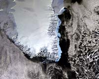
Greenbelt MD (SPX) Mar 19, 2006 NASA scientists said they have confirmed that climate warming is changing how much water remains locked in the Antarctic and Greenland ice sheets. Using radar altimeter data from ESA's ERS-1 and ERS-2 satellites, Jay Zwally and colleagues at NASA's Goddard Space Flight Center mapped the height of the polar ice sheets and found there was a net loss of ice between 1992 and 2002 and a corresponding rise in sea level. Polar ice plays a crucial role in regulating global climate, because it reflects about 80 percent of incoming sunlight. As the polar ice caps melt, ocean water absorbs a large part of the radiation energy, leading to further melting of the ice - and further warming of the climate. Reporting in the March issue of the Journal of Glaciology, the team said about 20 billion net tons of water are added to oceans each year from Greenland's ice sheet, which retains some 11 billion tons of water annually, while Antarctica loses about 31 billion tons per year. The scientists have found that Antarctica lost much more ice to the sea during that period than it gained from snowfall, resulting in an increase in sea level. The Greenland sheet gained more ice from snowfall at high altitudes than it lost from melting ice along its coast. Another study, by Eric Rignot of NASA's Jet Propulsion Laboratory in Pasadena, Calif., and Pannir Kanagaratnam of the University of Kansas in Lawrence, and published in the Feb. 17 issue of the journal Science, showed Greenland glaciers are melting into the sea twice as fast as previously believed. Using satellite data collected between 1996 and 2005 by ESA's ERS-1, ERS-2 and Envisat, and Canada's Radarsat-1, they found Greenland's southern glaciers are now dumping twice as much ice yearly into the Atlantic as they did in 1996, accounting for nearly 17 percent of the estimated 2.54 millimeter annual rise in global sea levels. The fact that the Greenland glaciers are melting, as determined in Rignot's study, coupled with the new findings that Greenland's glaciers are gaining more snow at the top, suggests global warming is affecting the ice sheets, Zwally and colleagues have concluded. When Earth's climate warms, it builds up water in the atmosphere, which then can increase snowfall over Greenland. At the same time, however, ocean warming is causing the outer sheets of ice to melt. The question of whether and to what extent global climate change is causing the polar ice caps to shrink is one of the topics addressed last week by glaciologists, hydrologists, oceanographers and geodesists from around the world at the "15 Years of Progress in Radar Altimetry" symposium in Venice, Italy. For the last 15 years, radar altimetry � an instrument originally designed to measure the sea surface height � has measured large-scale homogenous ice surfaces of Greenland and Antarctica and provided initial global monitoring results for sea-ice thickness. In an effort to improve the understanding of the relationship between the Earth's ice cover and global climate, ESA designed a mission called CryoSat to provide detailed views of irregular sloping edges of land ice, as well as non-homogenous ocean ice over a three-year period. That mission was lost last Oct. 8, due to a malfunction of its Russian rocket launcher. On Feb. 24, ESA received the green light from its Member States to build and launch a CryoSat recovery mission, CryoSat-2. The new satellite will be equipped with an enhanced radar altimeter instrument, called the Synthetic Aperture Interferometric Radar Altimeter, or SIRAL, which will allow it to send 17,800 radar-pulses per second down to Earth, then record how long the echoes will take to bounce back. Currently, the second generation radar altimeter on ESA's Envisat measures height using the same technique, but emits only 1,800 pulses per second. Community Email This Article Comment On This Article Related Links NASA Goddard ERS ENVISAT ESA Space Technology News - Applications and Research
Blue Sky Network has announced that Steve Fossett's latest record-breaking flight attempt will rely on its satellite based flight tracking, voice, mapping and telemetry solutions. Fossett took off this morning from Salina, Kansas to set the "Absolute Closed Circuit Distance Record" and will land on Thursday back in Salina. |
|
| The content herein, unless otherwise known to be public domain, are Copyright 1995-2006 - SpaceDaily.AFP and UPI Wire Stories are copyright Agence France-Presse and United Press International. ESA PortalReports are copyright European Space Agency. All NASA sourced material is public domain. Additionalcopyrights may apply in whole or part to other bona fide parties. Advertising does not imply endorsement,agreement or approval of any opinions, statements or information provided by SpaceDaily on any Web page published or hosted by SpaceDaily. Privacy Statement |