 |
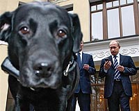
Moscow (RIA Novosti) Oct 20, 2008 Russian Prime Minster Vladimir Putin's black Labrador, Connie, has been given a tracking collar linked to the Russian navigation satellite system Glonass, the government website said on Friday. Glonass (Global Navigation Satellite System), Russia's equivalent of the U.S. Global Positioning System (GPS), is designed for both military and civilian use and allows users to identify their positions in real time. "I have to say that I am a touch late, as I promised [in March] to give Connie the collar this summer. In the interests of fairness, however, I should point out that it was ready - I just didn't have the chance to meet with you and Connie. The collar is ready, and we are ready to demonstrate it, fit it, and test it," Deputy First Prime Minister Sergei Ivanov told Putin at a meeting to discuss the development of Glonass. Ivanov said the collar was the "only one of its type in the world." Putin then put the collar, weighing 170 grams, on Connie, who was also present at the meeting. "Come here Connie, they've brought you a present," said Putin, noting that, "She's wagging her tail, that means she likes it." Ivanov also said that when Connie was stationary, for example, "in the forest, lying in a puddle" then the collar's battery would switch itself off, thereby conserving energy. "My dog is not a piglet, she doesn't lie in puddles," retorted Putin. The system, Ivanov said, may also be eventually used with dogs from the Russian emergencies ministry when they look for survivors after disasters. The Glonass system is set to cover the whole of Russia by the end of the year, Ivanov also said at the meeting. "Before the end of the year we are planning to launch another three [satellites], after which it will be possible to say with confidence that the entire territory of the Russian Federation will be reliably, fully, and around-the-clock covered by the Glonass signal from space," he said. Glonass, the Russian equivalent of the GPS navigation system, was launched in 1993, although it largely fell into disrepair in the 1990s. In 2001, in partnership with India, Russia set about updating the system.
Source: RIA Novosti Community Email This Article Comment On This Article Share This Article With Planet Earth
Related Links Glonass (Global Navigation Satellite System) GPS Applications, Technology and Suppliers
Users of ESRI's RouteMAP IMS software can now access local weather from WeatherBug, the largest weather sensor and camera network in the world, headquartered in Germantown, Maryland. With a network of 8,000 tracking stations, WeatherBug provides up-to-date local weather throughout the United States. |
|
| The content herein, unless otherwise known to be public domain, are Copyright 1995-2007 - SpaceDaily.AFP and UPI Wire Stories are copyright Agence France-Presse and United Press International. ESA Portal Reports are copyright European Space Agency. All NASA sourced material is public domain. Additional copyrights may apply in whole or part to other bona fide parties. Advertising does not imply endorsement,agreement or approval of any opinions, statements or information provided by SpaceDaily on any Web page published or hosted by SpaceDaily. Privacy Statement |
 del.icio.us
 Digg
Digg Reddit
 YahooMyWeb
 Google