|
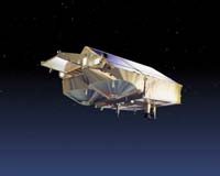
Paris, France (ESA) Oct 07, 2004 Due for launch next spring, ESA's ice mission CryoSat marked an important milestone last week when the innovative SAR/Interferometric Radar Altimeter (SIRAL) instrument was delivered to the prime contractor EADS Astruim GmbH for integration into the satellite. Developed by Alcatel Space, the SIRAL radar altimeter is the key instrument to be carried on the CryoSat mission. Its design is based on heritage from existing radar altimeters but with a number of sophisticated enhancements to overcome the challenges of measuring two different kinds of ice cover. SIRAL will be able to acquire very precise measurements of the thickness of relatively thin floating sea-ice so that annual variations can be observed, and also accurately survey the surface of polar ice-sheets, which are kilometres thick, in order to detect any small changes. CryoSat is the first Earth Explorer satellite to be launched as part of ESA's Living Planet Programme. It is now generally agreed that the Earth's atmosphere is warming, however, it is very difficult to predict what effect this is having on polar ice cover. Since ice plays such an important role in the regulation of the Earth's climate and sea-level height, it is crucial to determine any change in the thickness of marine and continental ice cover. Orbiting the Earth at an unusually high inclination and reaching latitudes of 88� North and South on every orbit, CryoSat will provide estimates of sea-ice thickness for the whole Arctic basin and monitor thickness changes in ice sheets, particularly around the edges where icebergs break off. The main aim of the mission is to provide conclusive evidence as to whether the ice is really thinning and consequently advance our understanding of the relationship between ice and global climate. In order to meet the mission's demanding measuring requirements, an extremely specialised radar altimeter had to be developed and the result is the highly innovative SIRAL instrument. Weighing just 70 kilograms, it combines three measurement modes:
The CryoSat satellite is currently undergoing final environmental testing at the Space Test Centre at IABG (Industrieanlagen Betriebsgellschaft mbH) and now that the key SIRAL instrument has been delivered, integration will begin shortly. Guy Ratier, ESA's CryoSat Project Manager said, "Indeed, the arrival of the flight model of SIRAL at IABG is a major step in the assembly and integration activities of the CryoSat Satellite." "We are all eager to see this complex payload being operated with the spacecraft. Performance predictions are excellent and based on tests performed so far with the engineering model, we are quite confident of the successful outcome of the integration campaign starting now." CryoSat is due to be shipped to the launch site in Plesetsk, Russia in mid-February ready for launch, which is scheduled for 25 March 2005. Community Email This Article Comment On This Article Related Links CryoSat SpaceDaily Search SpaceDaily Subscribe To SpaceDaily Express Earth Observation News - Suppiliers, Technology and Application
 New York NY (SPX) Jan 11, 2006
The importance of remotely sensed data and technologies to support natural disasters has prompted attention and action in Washington. New initiatives and legislation authorizing appropriations to the remote sensing industry will be discussed at Strategic Research Institute's U.S. Commercial Remote Sensing Industry conference, scheduled for February 9-10, 2006 in Washington D.C. |
|
| The content herein, unless otherwise known to be public domain, are Copyright 1995-2006 - SpaceDaily.AFP and UPI Wire Stories are copyright Agence France-Presse and United Press International. ESA PortalReports are copyright European Space Agency. All NASA sourced material is public domain. Additionalcopyrights may apply in whole or part to other bona fide parties. Advertising does not imply endorsement,agreement or approval of any opinions, statements or information provided by SpaceDaily on any Web page published or hosted by SpaceDaily. Privacy Statement |