|
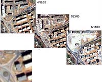
Longmont - Oct 01, 2003 A new study documents the potential high-resolution QuickBird satellite imagery from DigitalGlobe can bring to post-earthquake damage detection and recovery efforts. The study, conducted by ImageCat, Inc., was partially funded by the Multidisciplinary Center for Earthquake Engineering Research (MCEER) headquartered at the University at Buffalo. The Earthquake Engineering Research Institute (EERI), through its "Learning from Earthquakes" program, provided imagery to ImageCat, the University of Tokyo and several other research organizations around the world involved in the use of remote sensing for disaster response. This combined effort represents a significant milestone in the field of earthquake research. For several years, researchers at ImageCat have investigated how remote sensing technologies can improve response and recovery activities after major earthquakes. This research has focused on various aspects of damage detection, including the distinction between extreme damage versus non-damage states, the quantification of damage states on a regional basis, and the assessment of damage sustained by individual buildings. In the study just- released by EERI and MCEER, satellite imagery is identified as an effective and valuable tool in the response and recovery phases of the emergency management cycle for reconnaissance and monitoring recovery operations. To conduct its research, ImageCat used the events of May 21, 2003, when an earthquake measuring 6.8 on the Richter scale rocked Algeria -- drastically affecting the towns of Rouiba, Boumerdes and Thenia, among others. In its wake, the first priority was to assess and limit human injuries and fatalities, a monumental effort considering the total death toll reached 2,266 with 10,261 injured. Structural damage assessment and recovery was also a priority as 214 commercial buildings and 1,029 individual residences were destroyed. To evaluate the potential of satellite imagery to assist in this assessment and its possible use for coordination of site visits and relief efforts, the researchers turned to DigitalGlobe, provider of the world's highest resolution commercial satellite imagery that boasts a vast, up-to-date archive of digital images. EERI acquired before and after QuickBird data, including imagery dated April 22, 2002 -- approximately one year prior to the earthquake -- and May 23, 2003 -- two days after. QuickBird imagery captured on June 18, 2003 enabled the further assessment of high-resolution imagery for monitoring recovery efforts during the following month. During the evaluation phase, automated change detection algorithms were created, offering a "quick-look" damage assessment and providing the focus for more detailed inspection of building damage using visualization techniques. A visual comparison was then drawn between enlarged views of the before and after QuickBird images, which were displayed side by side within Research Systems' ENVI image processing environment. Due to the extremely detailed representation offered by QuickBird satellite imagery, severely damaged structures were readily identified. In addition to urban damage, the images also effectively showed the location of temporary tent camps housing displaced residents. Researchers hope to use such imagery in future events to provide "real time" assessments that will guide the work of field reconnaissance teams. Community Email This Article Comment On This Article Related Links The Earthquake Engineering Research Institute The Multidisciplinary Center for Earthquake Engineering Research DigitalGlobe SpaceDaily Search SpaceDaily Subscribe To SpaceDaily Express Earth Observation News - Suppiliers, Technology and Application
 New York NY (SPX) Jan 11, 2006
The importance of remotely sensed data and technologies to support natural disasters has prompted attention and action in Washington. New initiatives and legislation authorizing appropriations to the remote sensing industry will be discussed at Strategic Research Institute's U.S. Commercial Remote Sensing Industry conference, scheduled for February 9-10, 2006 in Washington D.C. |
|
| The content herein, unless otherwise known to be public domain, are Copyright 1995-2006 - SpaceDaily.AFP and UPI Wire Stories are copyright Agence France-Presse and United Press International. ESA PortalReports are copyright European Space Agency. All NASA sourced material is public domain. Additionalcopyrights may apply in whole or part to other bona fide parties. Advertising does not imply endorsement,agreement or approval of any opinions, statements or information provided by SpaceDaily on any Web page published or hosted by SpaceDaily. Privacy Statement |