|
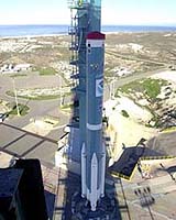
Vandenberg AFB CA (SPX) May 03, 2005 The latest polar-orbiting operational environmental satellite developed by NASA for the National Oceanic and Atmospheric Administration (NOAA), called NOAA-N, is set to be launched on May 11, from Vandenberg Air Force Base, California, between 3:22:01 to 3:32:01 a.m. PDT. NOAA-N is the latest satellite in the advanced TIROS-N (ATN) series. The spacecraft will continue to provide a polar-orbiting platform to support (1) environmental monitoring instruments for imaging and measuring the Earth's atmosphere, its surface, and cloud cover, including Earth radiation, atmospheric ozone, aerosol distribution, sea surface temperature, and vertical temperature and water profiles in the troposphere and stratosphere; (2) measurement of proton and electron flux at orbit altitude; (3) data collection from remote platforms; and (4) the Search and Rescue Satellite-Aided Tracking (SARSAT) system. Additionally, NOAA-N is the fourth in the series of support dedicated microwave instruments for the generation of temperature, moisture, surface, and hydrological products in cloudy regions where visible and infrared (IR) instruments have decreased capability. The satellite will be launched from the Western Range at Vandenberg AFB by a two-stage Boeing Delta II 7320-10 space launch vehicle. NOAA-N is the latest satellite in the Advanced Television Infrared Observational Satellites - N (ATN) series built by Lockheed Martin Space Systems Company. This spacecraft will continue to provide a polar-orbiting platform to support environmental monitoring instruments for imaging and measuring the Earth's atmosphere, its surface and cloud cover, including Earth radiation, atmospheric ozone, aerosol distribution, sea surface temperature, and vertical temperature and water profiles in the troposphere and stratosphere. It will assist in measuring proton and electron flux at orbit altitude, collecting data from remote platforms and will assist the Search and Rescue Satellite-Aided Tracking system. Additionally, NOAA-N is the fourth in the series to support dedicated microwave instruments for the generation of temperature, moisture, surface, and hydrological products in cloudy regions where visible and infrared instruments have decreased capability. Once on orbit, NOAA-N will be renamed NOAA-18 and will provide measurements of the Earth's surface and atmosphere that will be entered into NOAA's weather forecasting models and used for other environmental studies. Each day, polar-orbiting operational environmental satellites send global measurements to NOAA's Command and Data Acquisition station computers, adding vital information to forecasting models, especially over the oceans, where conventional data is lacking. Community Email This Article Comment On This Article Related Links GOES POES Program at NASA POES mission at NOAA SpaceDaily Search SpaceDaily Subscribe To SpaceDaily Express Earth Observation News - Suppiliers, Technology and Application
 New York NY (SPX) Jan 11, 2006
The importance of remotely sensed data and technologies to support natural disasters has prompted attention and action in Washington. New initiatives and legislation authorizing appropriations to the remote sensing industry will be discussed at Strategic Research Institute's U.S. Commercial Remote Sensing Industry conference, scheduled for February 9-10, 2006 in Washington D.C. |
|
| The content herein, unless otherwise known to be public domain, are Copyright 1995-2006 - SpaceDaily.AFP and UPI Wire Stories are copyright Agence France-Presse and United Press International. ESA PortalReports are copyright European Space Agency. All NASA sourced material is public domain. Additionalcopyrights may apply in whole or part to other bona fide parties. Advertising does not imply endorsement,agreement or approval of any opinions, statements or information provided by SpaceDaily on any Web page published or hosted by SpaceDaily. Privacy Statement |