|
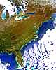
Dulles Va - August 7, 1998 - Orbital Imaging Corporation (OrbImage) announced Thursday that its OrbView-2 Earth imaging satellite has successfully completed its first year in space. Launched on August 1, 1997, OrbView-2 is the world's first commercial satellite to provide high-performance multispectral imagery, such as daily color images of the Earth's oceans and land areas. During its first year of operations, OrbView-2 has provided greater than 98% satellite imaging availability as it completed over 5,000 revolutions of the Earth. The satellite has acquired over 45,000 individual scenes making up more than 300 complete global image sets, enabling OrbImage to establish a strong foothold in markets including precision high-seas fishing, agriculture management, naval operations, environmental monitoring, and various scientific applications. OrbView-2 has an exceptional ability to acquire color imagery of the Earth with eight multispectral imaging channels. One important product produced from OrbView-2 imagery is fish finding maps, which are sold on a subscription basis to high-seas fishing vessels. These fishing maps use OrbView-2's ability to monitor plankton in the world's oceans to precisely indicate productive fishing areas for such fish as skipjack, yellowfin and albacore tuna. OrbImage's current customers for OrbView-2 fish finding maps include over 100 high-seas fishing vessels. These vessels are operated by companies located around the world, including the largest high-seas fishing companies in the United States, France, Spain, Japan, Korea and the Philippines. A typical fishing vessel using OrbView-2 fishing maps is an 800-ton fishing boat which receives the digital maps on a daily basis using the INMARSAT communications system, then displays and interprets the maps on-board the vessel using a personal computer running OrbImage's "OrbMap" display software. Mr. Gilbert D. Rye, President and Chief Operating Officer of OrbImage, said, "I am particularly proud of our fishing service production team who successfully produced over 2,000 customized fish finding maps during OrbView-2's first year of operations. OrbImage's team of oceanographers has done a great job refining our fishing service through direct feedback from the world's leading fishing captains. As we reflect on OrbView first year, we are pleased that the fishing service is already being widely adopted as a valuable productivity-enhancing asset in the worldwide fishing industry." Scientific applications are also an important aspect of the value of OrbView-2 imagery. For example, the National Aeronautics and Space Administration (NASA) is OrbImage's primary anchor customer for research uses of OrbView-2 data. Under a five-year $45 million data purchase agreement with OrbImage, NASA is using OrbView-2's global color imagery for research activities such as studying the impact of the world's oceans on global warming. NASA already has licensed over 300 researchers to receive and process OrbView-2 data through its SeaWiFS Project Office at Goddard Space Flight Center in Greenbelt, Maryland. In addition to fishing and scientific applications, OrbView-2 imagery is also beneficial for other operational uses. Examples include OrbView-2's ability to monitor water clarity, which is useful in assisting the U.S. Navy in selected naval operations; its ability to assess global vegetation health, which is valuable for crop yield estimation in several agricultural markets; and its ability to measure ocean-surface plankton, which is critical for monitoring "red tides" and coastal pollution levels. About OrbImage A subsidiary of Orbital Sciences Corporation, OrbImage is a leading global provider of satellite-delivered Earth imagery services with a planned constellation of four satellites. It currently operates the OrbView-1 atmospheric imaging satellite that was launched in 1995, the OrbView-2 ocean and land multispectral imaging satellite, and a common ground receiving, processing and distribution system. Over the next several years, OrbImage will launch and place into service the OrbView-3 and OrbView-4 advanced digital imaging satellites that will provide high-resolution photographs of the Earth's surface, as well as multispectral and hyperspectral imagery. Its OrbNet digital archive and electronic distribution system, which the company expects to activate later this year, will be an online catalog for the distribution and sales of imagery from each of the company's satellites to customers over the Internet.
Email This Article Comment On This Article Related Links Space
 Calcutta, India (SPX) Dec 28, 2005
The successful launch Thursday of India's heaviest satellite from spaceport of Kourou in French Guyana may have boosted the country's space research efforts to yet another level, but it has also lifted the spirits of at least three Direct-To-Home televisions broadcasters, one of which has been waiting for years to launch its services in India. |
|
|
|
|
|
|
|
|
|
|
|
|
|
| The content herein, unless otherwise known to be public domain, are Copyright 1995-2006 - SpaceDaily.AFP and UPI Wire Stories are copyright Agence France-Presse and United Press International. ESA PortalReports are copyright European Space Agency. All NASA sourced material is public domain. Additionalcopyrights may apply in whole or part to other bona fide parties. Advertising does not imply endorsement,agreement or approval of any opinions, statements or information provided by SpaceDaily on any Web page published or hosted by SpaceDaily. Privacy Statement |