|
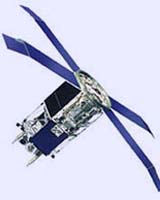
Dulles VA (SPX) Aug 20, 2004 OrbImage, the Dulles, a provider of satellite imagery and geospatial information services, announced Thursday that its OrbView-2 satellite recently passed its seventh successful year of operations with an unprecedented availability rate of over 98%. OrbImage expects OrbView-2 to continue providing service for at least another 3 to 5 years. Since its launch on August 11th, 1997, OrbView-2 has traveled over 1.6 billion kilometers (1 billion miles), made over 37,000 orbits around the Earth, and collected over 500 billion square kilometers of multispectral (color) imagery as it images the entire earth every day. OrbView-2's Wide Field of View Sensor (or "SeaWiFS") measures subtle changes in ocean color to help identify different types and quantities of marine phytoplankton - the microscopic marine plants at the bottom of the pelagic food chain - the knowledge of which has both scientific and commercial applications. Over 2,400 NASA program researchers around the world use OrbView-2 imagery to study the Earth's oceans and land mass. In addition to its scientific applications, OrbView-2 also supports meteorological applications (as the image of hurricane Charley represents) and OrbImage's commercial SeaStar Fisheries Information Service which uses the plankton information from OrbView-2 in conjunction with other ocean information sources to support over 260 fishing vessels worldwide in search of tuna and other species. "Both NASA and OrbImage have benefited greatly from our collaboration on OrbView-2," said Matthew O'Connell, OrbImage's CEO. "The satellite's design and reliability have provided both organizations with near real-time data that has provided nearly a decade of valuable research data on the earth's land and oceans as well as commercial products for the fishing industry. The satellite is in great condition, and we expect it will continue providing service for several more years." OrbView-2 was designed as a government-industry partnership, and has been a workhorse for both NASA and OrbImage. OrbImage's SeaStar Fisheries Information Service produces over 600,000 products per year and OrbView-2 imagery has been featured in numerous scientific journals, books, magazines and television news programs. It has captured many global events, including past and current hurricanes, wildfires, red tides, the eruptions of Mount Etna, and oil well fires in Iraq after the initial air strikes on Baghdad. OrbView-2 imagery can also be found in National Geographic's Atlas of the Ocean and in the Smithsonian Air and Space museum. OrbView-2 travels in a sun-synchronous orbit 705 km above the earth. OrbView-2 imagery has a spatial resolution of 1km and sample images from the satellite are available for viewing on OrbImage's website Community Email This Article Comment On This Article Related Links OrbImage SpaceDaily Search SpaceDaily Subscribe To SpaceDaily Express Earth Observation News - Suppiliers, Technology and Application
 New York NY (SPX) Jan 11, 2006
The importance of remotely sensed data and technologies to support natural disasters has prompted attention and action in Washington. New initiatives and legislation authorizing appropriations to the remote sensing industry will be discussed at Strategic Research Institute's U.S. Commercial Remote Sensing Industry conference, scheduled for February 9-10, 2006 in Washington D.C. |
|
| The content herein, unless otherwise known to be public domain, are Copyright 1995-2006 - SpaceDaily.AFP and UPI Wire Stories are copyright Agence France-Presse and United Press International. ESA PortalReports are copyright European Space Agency. All NASA sourced material is public domain. Additionalcopyrights may apply in whole or part to other bona fide parties. Advertising does not imply endorsement,agreement or approval of any opinions, statements or information provided by SpaceDaily on any Web page published or hosted by SpaceDaily. Privacy Statement |