|
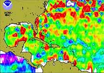
Boulder - October 18, 1999 - Using data from remote sensing satellites, researchers at the University of Colorado at Boulder are investigating a key factor that can be used in predicting the extent of a hurricane's fury. A hurricane's passage over a warm ocean eddy or current has been linked to a marked intensification of hurricane winds. Researchers at the Colorado Center for Astrodynamics Research in CU-Boulder's College of Engineering and Applied Science have been analyzing the relationship between warm ocean features and hurricane intensification using altimeter data from the TOPEX/POSEIDON and ERS-2 Earth-orbiting satellites. Caption Above Altimeter-Derived Sea Height Anomalies in the Western North Atlantic. These remote sensing satellites, which use a technique that measures the travel time of a microwave pulse reflected off the ocean's surface, help to detect the location of warm eddies and currents in real time, and thus are the latest tool in use by hurricane forecasters. Working with Gustavo Goni at the National Oceanic and Atmospheric Administration's Atlantic Oceanographic and Meteorological Laboratory, CCAR researchers under the direction of aerospace engineering professor George Born, are using the data to assist forecasters in predicting which storms are likely to hit coastal areas the hardest. While the ability to forecast a hurricane's path is relatively advanced, predicting intensity and storm surge -- information that could help determine evacuation areas and other safety measures -- has lagged behind because of insufficient data. A hurricane is born when the right atmospheric conditions are combined with sea surface temperatures exceeding 26 degrees C (79 degrees F), according to CCAR research assistant Suzanna Barth. Warm air rises off the surface of the water, creating an atmospheric low-pressure cell which, if near the equator, produces winds that bend poleward as a result of the earth's rotation. When a hurricane is then driven by high-altitude winds on a path over other warm water features, the additional heat may cause the storm to intensify. "Think of it as a steam engine -- the more heat that's put into it, the faster it's going to run," said associate research professor Robert Leben. A CCAR analysis of altimeter data revealed that during September 1995, Hurricane Opal's winds increased from 75 miles per hour to 145 miles per hour in only nine hours after the hurricane crossed a warm eddy in the Gulf of Mexico. Hurricane Floyd, also categorized as a Category 4 hurricane before it slammed into North Carolina in September 1999, crossed several warm water columns, building up power as it moved across the Atlantic. NOAA/AOML and CCAR researchers extrapolate sea surface temperatures and the approximate thickness of warm water from daily maps of sea surface height obtained through altimetry to estimate the hurricane heat potential in the ocean. Higher sea levels are associated with warm ocean features, Goni said. Effective even when clouds block infrared signals, satellite altimetry allows scientists to map sea surface height, geostrophic velocity, significant wave height and wind speed on all of the world's oceans in real time. When combined with sea surface temperature measurements from infrared radiometers, a complete picture of the ocean's hurricane heat potential can be derived. The Colorado Center for Astrodynamics Research is a multidisciplinary research center involving faculty, staff and students from the departments of aerospace engineering sciences and electrical and computer engineering at CU-Boulder. Founded in 1985, CCAR's research program emphasizes astrodynamics, satellite meteorology, oceanography, geodesy and terrestrial vegetation studies.
Email This Article Comment On This Article Related Links Space
 Calcutta, India (SPX) Dec 28, 2005
The successful launch Thursday of India's heaviest satellite from spaceport of Kourou in French Guyana may have boosted the country's space research efforts to yet another level, but it has also lifted the spirits of at least three Direct-To-Home televisions broadcasters, one of which has been waiting for years to launch its services in India. |
|
|
|
|
|
|
|
|
|
|
|
|
|
| The content herein, unless otherwise known to be public domain, are Copyright 1995-2006 - SpaceDaily.AFP and UPI Wire Stories are copyright Agence France-Presse and United Press International. ESA PortalReports are copyright European Space Agency. All NASA sourced material is public domain. Additionalcopyrights may apply in whole or part to other bona fide parties. Advertising does not imply endorsement,agreement or approval of any opinions, statements or information provided by SpaceDaily on any Web page published or hosted by SpaceDaily. Privacy Statement |