|
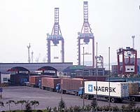
Calgary AB (SPX) May 17, 2005 NovAtel announced Monday that its dealer, Beijing BDStar Navigation, Beijing, China, completed deployment of NovAtel GPS-based systems for the Tianjin port Container Terminals (TCT), as per the terms of a contract awarded to BDStar in July 2004. NovAtel executives were on hand to present the Company's leading edge technology at the commissioning ceremony for TCT held last month. BDStar is also in initial deployment for a number of other port authorities in China, including ShenZhen and Hong Kong. "This new contract, along with an additional contract to install receivers on port-specific heavy machinery, such as Rubber Tire Gantries (RTG's) manufactured in China, builds on the number of customers worldwide using NovAtel for this demanding application. "We believe our success rates in these ports will continue to expand our opportunities with other Port Authorities in China," said Graham Purves, NovAtel's VP Sales. "Port LBS (Location Based Service) business is a strategic focus for BDStar. We have integrated BDStar's customized software services with NovAtel's accurate and reliable GPS technology to create a strong product offering for this market. "Add this to our increased efforts and resources directed towards the development of business in this application sector, and we believe we are poised to become a market leader," said Ruxin Zhou, BDStar's President. Under the TCT contract, NovAtel supplied ProPak-G2 dual frequency GPS receivers integrated with BDStar's custom Geographic Information System (GIS) database software. These receivers are key in the efficient management and operation of automated container placement. GPS allows for the automation of the pick-up, transfer and placement process by tracking containers from port entry to exit. Utilizing patented Pulse Aperture Correlator (PAC) positioning technology, NovAtel's ProPak receivers are used to locate containers and place them into planned positions before the next scheduled departure. With millions of container shipments being placed in port terminals annually, GPS technology can greatly reduce the number of lost or misdirected containers, improving safety of life conditions and reducing operating costs. "We implemented BDStar's 3C2S (3C:Computer, Communication and Control; 2S:GPS and GIS) system three months ago and have already seen direct benefits to our business," said LingSen Xue, TCT's General Manager. "We have documented a 4-8% decrease in costs and a 5-10% increase in efficiency." NovAtel's ProPak-G2 with PAC technology significantly reduces the effects of multipath - the last significant remaining error factor in precise positioning. Multiple models are available to meet a variety of positioning requirements, including single and dual frequency, and optional support for Satellite Based Augmentation Systems (SBAS) corrections from WAAS and EGNOS systems. Community Email This Article Comment On This Article Related Links NovAtel SpaceDaily Search SpaceDaily Subscribe To SpaceDaily Express GPS Applications, Technology and Suppliers
 Cheltenham, England (SPX) Jan 09, 2006
Marotta UK is pleased to announce that it designed, developed and qualified equipment for the cold gas propulsion systems on board the Galileo GIOVE-A, part of Europe's Galileo navigation program, successfully launched by Surrey Satellite Technology (SSTL). |
|
| The content herein, unless otherwise known to be public domain, are Copyright 1995-2006 - SpaceDaily.AFP and UPI Wire Stories are copyright Agence France-Presse and United Press International. ESA PortalReports are copyright European Space Agency. All NASA sourced material is public domain. Additionalcopyrights may apply in whole or part to other bona fide parties. Advertising does not imply endorsement,agreement or approval of any opinions, statements or information provided by SpaceDaily on any Web page published or hosted by SpaceDaily. Privacy Statement |