|
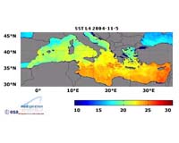
Paris France (SPX) Mar 17, 2006 ESA scientists have switched their satellite surveys to nighttime to obtain better data on the temperature of the Mediterranean Sea and elsewhere in the waters surrounding Europe. The space agency's Earth scientists consider sea-surface temperature an important index for weather and ocean forecasting, and a key indicator of climate change. So ESA developed the Medspiration project to combine data from multiple satellite systems to produce sea-surface data for the waters around Europe and also the whole of the Atlantic Ocean. Medspiration is a cooperative effort designed to provide near-real-time data to improve ocean forecasts, in the same way atmospheric models rely on satellite and on-the-ground surveys. The project is now making available a daily, ultra-high-resolution sea-surface temperature map focused on the Mediterranean Sea that is accurate to within 0.3 degree Celsius. The project employs infrared instruments aboard ESA's Envisat to acquire sea-surface temperature readings in kilometer-square grids of ocean and provides readings accurate to within 0.2 degrees Celsius. Medspiration also employs data from the Spinning Enhanced Visible and Infra-Red Imager SEVIRI aboard Meteosat-8; two Advanced Very High Resolution Radiometer sensors on polar orbiters operated by the U.S. National Oceanic and Atmospheric Administration, and a pair of Japanese-built instruments: the Advanced Microwave Scanning Radiometer, and the Tropical Rainfall Measuring Mission's microwave imager aboard NASA's Aqua and the JAXA-NASA TRMM spacecraft, respectively. Medspiration data have been available to users since November 2004, but project managers said Friday they have activated "significant" quality enhancements since last January. Those enhancements include 2-square-kilometer (0.77 square mile) resolution imagery over the Atlantic Ocean to match the grid of a major ocean forecasting model run by Italy's National Institute for Geophysics and Volcanology. ESA scientists said they began the nighttime surveys because the instruments can measure water temperature only to a seawater depth to about 10 to 20 microns (thousandths of a meter). During the daytime, incoming solar radiation heats the topmost water layers, setting up steep temperature gradients that can mislead satellite instruments. The gradients dissipate during the night and minimize at dawn, which is when heat-measuring satellite sensors such as radiometers get closest to taking the temperature of deeper water layers. Oceanographers are most interested in readings from those deeper layers, because they are thought to be more influential on climate change. "Medspiration now provides ultra-high resolution SST products covering nearly all the European seas in addition to a substantial part of the north-east Atlantic," said Craig Donlon, head of the GHRSST-PP office. "This should help European NWP and ocean forecasting systems improve their services in the coming months. Medspiration is being run as a demonstration project up until the end of 2007, with user consultations taking place every six months � the next scheduled for June. Mission scientists plan to extend the project to cover a range of other data, including water quality, algal blooms and oil-spills. Community Email This Article Comment On This Article Related Links Medspiration ESA ENVISAT SEVIRI AMSR TRMM Earth Observation News - Suppiliers, Technology and Application
 Paris France (SPX) Mar 19, 2006
ESA will unveil a frieze depicting the entire planet Earth, made up of one-millionth-scale satellite images, around UNESCO's headquarters building on March 29. |
|
| The content herein, unless otherwise known to be public domain, are Copyright 1995-2006 - SpaceDaily.AFP and UPI Wire Stories are copyright Agence France-Presse and United Press International. ESA PortalReports are copyright European Space Agency. All NASA sourced material is public domain. Additionalcopyrights may apply in whole or part to other bona fide parties. Advertising does not imply endorsement,agreement or approval of any opinions, statements or information provided by SpaceDaily on any Web page published or hosted by SpaceDaily. Privacy Statement |