 |
Sweden (SPX) Mar 15, 2005 A new method for navigation at sea, independent of GPS, is being put forward in a dissertation from Linkoping University. Today merchant marine, military, and recreational boat traffic all rely on the global satellite system GPS to determine their position at sea. But sometimes information from the system is incorrect. Poor visibility or lax attention can then spell disaster. GPS can be jammed, either unintentionally or intentionally. Signals from the satellites can be interfered with by ice build-up on the vessel's antennas, by other communication equipment, or by physical obstacles. Submarines cannot usually use the system. Doctoral student Rickard Karlsson at the Center for Control and Communication describes in his thesis how modern, simulation-based methods of treating signals can be used to monitor and, if necessary, to take over the GPS function on a vessel. This technology, unique in the world, requires no external infrastructure and is not susceptible to interference. Instead, the vessel's own radar is used to measure the distance to surrounding shores, and this data is then compared with a digital sea chart. In a submarine, information from sonar equipment is compared with a digital depth chart. In combination with data about the movement of the vessel, the correct position can be calculated. The method is based on a mathematical algorithm, a so-called particle filter, which is installed as a program in the vessel's computer system. There is no need for any further hardware to be installed beyond what is already on board. Preliminary trials show that the method works just as well as GPS in navigating an archipelago. The dissertation Particle Filtering for Positioning and Tracking Applications deals with several other uses of the same principle: positioning industrial robots, tracking vehicles from another vehicle to avoid collisions, and tracking boats and ships from an airplane. Community Email This Article Comment On This Article Related Links Swedish Research Council SpaceDaily Search SpaceDaily Subscribe To SpaceDaily Express GPS Applications, Technology and Suppliers
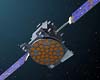 Cheltenham, England (SPX) Jan 09, 2006
Marotta UK is pleased to announce that it designed, developed and qualified equipment for the cold gas propulsion systems on board the Galileo GIOVE-A, part of Europe's Galileo navigation program, successfully launched by Surrey Satellite Technology (SSTL). |
|
| The content herein, unless otherwise known to be public domain, are Copyright 1995-2006 - SpaceDaily.AFP and UPI Wire Stories are copyright Agence France-Presse and United Press International. ESA PortalReports are copyright European Space Agency. All NASA sourced material is public domain. Additionalcopyrights may apply in whole or part to other bona fide parties. Advertising does not imply endorsement,agreement or approval of any opinions, statements or information provided by SpaceDaily on any Web page published or hosted by SpaceDaily. Privacy Statement |
