|
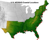
Boulder CO (SPX) May 22, 2007 Forecasters will test a new technique this summer that provides a detailed 3-D view of an approaching hurricane every six minutes and allows them to determine whether the storm is gathering strength as it nears land. The technique, developed by researchers at the National Center for Atmospheric Research (NCAR) and the Naval Research Laboratory (NRL), relies on the existing network of Doppler radars along the Southeast coast to closely monitor hurricane winds. "With this technique, meteorologists for the first time will be able to monitor the strength of a hurricane every few minutes as it approaches landfall and quickly alert coastal communities if it suddenly intensifies or weakens," says NCAR scientist Wen-Chau Lee. The technique is known as VORTRAC, which stands for Vortex Objective Radar Tracking and Circulation. VORTRAC uses the Doppler radar network established by the National Oceanic and Atmospheric Administration (NOAA) in the 1980s and 1990s. About 20 of these radars are scattered along the Gulf and Atlantic coastlines from Texas to Maine. Each radar can measure winds blowing toward or away from it, but no single radar could provide a 3-D picture of hurricane winds before now. Lee and his collaborators developed a series of mathematical formulas that combine data from a single radar near the center of a landfalling storm with general knowledge of Atlantic hurricane structure in order to map the approaching system's winds in three dimensions. The technique also infers the barometric pressure in the eye of the hurricane, a very reliable index of its strength. Forecasters using VORTRAC can update information about a hurricane each time a NOAA Doppler radar scans the storm, which can be as often as about every six minutes. Without such a technique, forecasters would need at least two coastal radars in close proximity to each other in order to obtain the same information. But most of the network's radars are too far apart to qualify. Because of the limited range of Doppler radars, VORTRAC works only for hurricanes that are within about 120 miles of land. Depending on a hurricane's speed, that could enable forecasters to monitor it for the critical 10-15 hours or so before landfall. The National Hurricane Center will test VORTRAC during this year's hurricane season, which officially starts on June 1. To monitor the winds of a landfalling hurricane, forecasters now rely on aircraft to drop instrument packages into the storm that gather data on winds and pressure. But due to flight logistics, the aircraft can take readings no more than every few hours, which means that coastal communities may not be swiftly alerted to changes in approaching hurricanes. In 2004, parts of Florida's southwest coast were caught by surprise when Hurricane Charley's top winds increased from 110 to 145 miles per hour in just six hours as the storm neared land. Lee and his collaborators applied VORTRAC retroactively to Hurricane Charley. In a recent article in Geophysical Research Letters, they reported that the technique would have accurately captured the burst in the hurricane's intensity. "Our research shows that this technique can capture sudden intensity changes in potentially dangerous hurricanes," says NCAR scientist Michael Bell, a coauthor of the article. In time, VORTRAC may also help improve long-range hurricane forecasts by using data from airborne radars to produce detailed information about a hurricane that is far out to sea. Forecasters could input the data to computer models to improve three- and five-day forecasts. The research was funded primarily by the National Science Foundation and NOAA. Email This Article
Related Links |
|
| The content herein, unless otherwise known to be public domain, are Copyright 1995-2006 - SpaceDaily.AFP and UPI Wire Stories are copyright Agence France-Presse and United Press International. ESA PortalReports are copyright European Space Agency. All NASA sourced material is public domain. Additionalcopyrights may apply in whole or part to other bona fide parties. Advertising does not imply endorsement,agreement or approval of any opinions, statements or information provided by SpaceDaily on any Web page published or hosted by SpaceDaily. Privacy Statement |