|
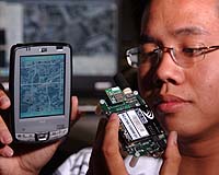
Washington DC (SPX) Apr 17, 2006 The old technique of using push pins and maps to track troop movements just got a radical new upgrade for soldiers or firefighters in rugged terrains. A group of University of Florida engineering students has designed a system to locate, track and communicate with special forces troops or firefighters in remote areas where no cell towers or other communications infrastructure exist. The system allows soldiers or firefighters to pinpoint their own and their comrades' whereabouts on digital maps displayed on handheld personal digital assistants. It can transmit this information via satellite phone, making it available to Internet-connected commanders or observers anywhere in the world. It even gives users the option of punching a panic button or sending text messages such as "need more water," "pull me out," or simply "help!" "It's live and it's in real time," said UF electrical and computer engineering senior Rolando Estrella. Estrella is among seven UF engineering seniors who spent the semester creating the system as part of the College of Engineering's Integrated Product & Process Design program. The 11-year-old program's goal is to assist corporations, small businesses and government agencies with engineering problems while giving engineering students practical experience working on real-world projects. The team was sponsored by defense contractor WinTec Arrowmaker Inc., Chang Industries, U.S. Special Operations and the U.S. Forest Service. Karl Gugel, a lecturer in electrical and computer engineering and the faculty leader, said the U.S. Forest Service's goal was to explore ways to upgrade its World War II-era equipment, which for communications purposes consists of traditional two-way radios. "You wouldn't believe how crude their equipment really is," he said. The team sought to design an inexpensive system using off-the-shelf equipment or parts that would function in areas with no other available communications technology. The technology also had to be easy to use, robust and secure. To achieve that goal, team members created a system with several different parts. Each firefighter carries a "FieldUnit," a cellphone-sized device equipped with a Global Positioning System. The unit communicates via radio signal with a "SmartNode," a nearby laptop equipped with radio transmitter and receiver. The laptop then transmits this information via satellite phone or other means if available. At its most stripped-down, the system provides only location information for firefighters or soldiers to observers elsewhere. But users can add the PDAs to their FieldUnits. That gives them the capability to send messages and see their locations on road maps, terrain maps or satellite maps � whatever happens to be available for the area. In theory, FieldUnits could also add sensors, such as temperature gauges, or even cameras. The project presented multiple challenges; chief among them was making sure the communications links functioned smoothly and consistently. For example, the students had to write special software to ensure that multiple FieldUnits could communicate with the SmartNode without any "calls" being dropped or lost. In a demonstration using recorded data, the system tracked two students moving around UF's Reitz Student Union North Lawn, their whereabouts visible on an aerial map displayed on a laptop. The students also demonstrated the panic button and instant messaging live. Significant technical hurdles remain � especially the system's relatively short range. The radio signals are weak, meaning the SmartNode has to be located within about a mile of the FieldUnits, even less if the terrain is mountainous or contains other large obstacles. Although this problem could be solved using multiple SmartNodes, another idea is to place the nodes atop airborne drones, which could circle the area containing the soldiers or firefighters to enable their communications. The students said they spent 20 to 30 hours weekly working on the project since the start of the semester. The project differed from engineering classes because the work was so applied, they said. "It was tough at times, but when the final product is a representation of our planning, design and hard work, it's well worth it," said electrical and computer engineering senior Michael Kessler. The other students in the "Florida Flamers" team were William Goh, Zachery Jacobson, Julie Ramirez, Adnan Rashid and Andrew Sciullo. Community Email This Article Comment On This Article Related Links University of Florida GPS Applications, Technology and Suppliers
 New Delhi, India (SPX) Apr 13, 2006
India and Russia are discussing whether to add a military element to the Global Navigation Satellite System, which currently is limited to civil cooperation, a Russian official told the Indian newspaper The Hindu reported Monday. |
|
| The content herein, unless otherwise known to be public domain, are Copyright 1995-2006 - SpaceDaily.AFP and UPI Wire Stories are copyright Agence France-Presse and United Press International. ESA PortalReports are copyright European Space Agency. All NASA sourced material is public domain. Additionalcopyrights may apply in whole or part to other bona fide parties. Advertising does not imply endorsement,agreement or approval of any opinions, statements or information provided by SpaceDaily on any Web page published or hosted by SpaceDaily. Privacy Statement |