|
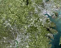
Greenbelt - May 30, 2001 A major advance in satellite-based land surface mapping has led to the creation of more accurate and detailed maps of our cities. These maps provide urban planners with a better understanding of city growth and how rainfall runoff over paved surfaces impact regional water quality. Maps taken from space are invaluable to city planners and state agencies monitoring water quality in urban areas, and are replacing the more expensive and time-consuming traditional aerial photography. These space-based maps of buildings and paved surfaces, such as roads and parking lots, which are impervious to water, can indicate where large storm water runoffs occur. Concentrated amounts of runoffs lead to erosion and elevated amounts of soil and chemical discharge into rivers, streams and ground water. Scott Goetz, Project Manager of the NASA-sponsored Mid-Atlantic Regional Earth Science Applications Center (RESAC) at the University of Maryland, presented these highly detailed surface maps today at the American Geophysical Union spring meeting, Boston, MA. Andrew Smith, a faculty research assistant working with Goetz at the Mid-Atlantic RESAC, developed a faster and less expensive capability, utilizing Landsat 7 and Space Imaging's Ikonos satellite data, to generate accurate maps of paved surfaces. "It's a major advance in monitoring capability because aerial photo mapping can't keep up with the pace of change," Goetz said. "Our maps of counties and cities capture new development and can be repeated much more quickly than the tedious and expensive traditional photo interpretation work." Urban sprawl results in more paved surfaces and less area for water to drain into soils. Reduced drainage areas bring more water into fewer drainage systems at a faster rate, eroding the banks of streams and rivers, and adding more sediment into the water. "If you increase an impervious surface near a stream by creating a paved parking lot, for example, you directly affect the quality of life in the stream because of the runoff that surface will generate," Goetz said. Smith cites previous researchers who have shown a relationship between the amounts of impervious surface cover within a watershed and the quality of surface water within that watershed. Generally, when 10 percent to 15 percent of an area is covered by impervious surfaces, the increased sediment and chemical pollutants in runoff have a measurable effect on water quality. When 15 percent to 25 percent of a watershed is paved or impervious to drainage, increased runoff leads to reduced oxygen levels and harms stream life. When more than 25 percent of surfaces are paved, many types of macro and microorganisms in streams die from concentrated runoff and sediments. Impervious surface maps also are useful in mapping urban sprawl. Sprawl is indicated on the maps by increases in land consumption and housing construction. By monitoring an area over time, maps can show the progress of residential development. Currently, the RESAC team is working with planning departments to add the data from the maps into future urban planning models. Smith has produced a map of the Washington-Baltimore area that quantifies how much impervious surface there is across the entire region. Baltimore and the counties that border it have at least 20 percent, and up to 40 percent, impervious surface area, indicating that pollution from runoff could be a problem. The District of Columbia and surrounding watersheds in Virginia and Maryland have levels of impervious surfaces between 20 percent and 30 percent percent. Areas between and beyond the Baltimore-Washington corridor are more "green" with levels that range from 0 percent to 20 percent impervious surface areas. The RESAC team has provided maps to the Chesapeake Bay Program, Maryland's Departments of Planning and Natural Resources and Montgomery County Department of Environment, among others, to monitor water quality and changes in residential land use. These organizations incorporate the impervious surface area data into models that predict water quality, future land use and the potential effectiveness of various "smart growth" policies. NASA launched Landsat 7 in April, 1999. Images are archived, processed, and distributed by the U.S. Geological Survey, which is also responsible for day-to-day operations of the satellite. This research is being conducted as part of NASA's Earth Science Enterprise, a long-term study of how natural and human-induced change affects our global environment. Community Email This Article Comment On This Article Related Links Series of Explanatory Images and Charts Landsat at Goddard SpaceDaily Search SpaceDaily Subscribe To SpaceDaily Express Dirt, rocks and all the stuff we stand on firmly
 Paris (ESA) Jan 12, 2006
Using the ESA Cluster spacecraft and the NASA Wind and ACE satellites, a team of American and European scientists have discovered the largest jets of particles created between the Earth and the Sun by magnetic reconnection. This result makes the cover of this week's issue of Nature. |
|
|
|
|
|
|
|
|
|
|
|
|
|
| The content herein, unless otherwise known to be public domain, are Copyright 1995-2006 - SpaceDaily.AFP and UPI Wire Stories are copyright Agence France-Presse and United Press International. ESA PortalReports are copyright European Space Agency. All NASA sourced material is public domain. Additionalcopyrights may apply in whole or part to other bona fide parties. Advertising does not imply endorsement,agreement or approval of any opinions, statements or information provided by SpaceDaily on any Web page published or hosted by SpaceDaily. Privacy Statement |