|
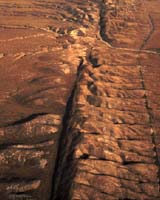
Leicester UK (SPX) Nov 13, 2006 A team from the University of Leicester has used a powerful laser mounted on an aircraft to uncover earthquake fault lines that are hidden by forest cover and never before seen by earth scientists. The 2005 Kashmir earthquake was a terrifying example of how faults in mountainous regions that pose serious seismic hazards can go unnoticed because they are hidden by forest cover and thus are not easily identified. Now the scientists from the Departments of Geology and Geography at the University of Leicester in the UK have developed a technique that can be used in mountainous terrain to virtually deforest the landscape and reveal details of the forest floor topography, including the traces of active faults. The scientists have pioneered use of the laser probe to map active fault systems in Europe and made the first ever use of the technique to survey high-relief alpine landscapes. The Leicester team has demonstrated that airborne LiDAR (an acronym for light detection and ranging - essentially a powerful laser mounted on an aircraft), can detect traces of active faults. Dr Dickson Cunningham in the Department of Geology and Dr Kevin Tansey in the Department of Geography collaborated on a NERC funded project to map the distribution of recently active earthquake-prone faults in the southeastern Alps in Slovenia. Their key research results are now published in the latest issue of Geophysical Research Letters. The work was further supported by a Masters student in Geography, Mr. Stephen Grebby. Dr Cunningham said: "Locating earthquake-prone faults in forested mountainous regions and understanding the potential seismic hazard they pose to local population centres has always been a problem to geoscientists. "Many regions of the world have undiscovered seismically active faults hidden by dense forests, including Indonesia, India, NW North America, all Andean nations and the alpine countries of Europe. Unfortunately for people living in these regions, these faults can be ticking time bombs. "We have demonstrated that airborne LiDAR can be used in mountainous terrain to virtually deforest the landscape and reveal details of the forest floor topography, including the traces of active faults." Dr Cunningham reports that the research involved collaborative efforts with Slovenian geoscientists and InfoTerra, a global geo-information supplier based in Leicester. The topographic images derived from LiDAR data of two major plate boundary faults, the Idrija and Ravne strike-slip faults in Slovenia, reveal geomorphological and structural features that shed light on the overall architecture and movement history of both fault systems. He added: "For the first time, we are able to see how the faults connect at the surface and cut the landscape. This allows us to assess whether the faults are likely to produce large earthquakes or small events in the future. The images also allow efficient identification of sites suitable for detailed fault analysis to calculate the recurrence interval of major earthquakes and make probabilistic estimates of the timing and magnitude of the next major earthquake." A field excursion in August 2006 verified the remote observations. Dr Tansey said: "As we trekked through the forest we found overwhelming evidence for previous fault activity, never before seen by earth scientists. We are now building on our initial results with follow-up research and have established the UK's first inter-disciplinary LiDAR research unit here at Leicester with support from the Ordnance Survey and the British Geological Survey." Community Email This Article Comment On This Article Related Links University of Leicester When the Earth Quakes Bringing Order To A World Of Disasters When the Earth Quakes A world of storm and tempest
 Sydney (AFP) Nov 9, 2006
The Pacific Ocean has given birth to a new volcanic island near Tonga, according to ocean-going eyewitnesses. Crew on board a yacht called the "Maiken" believed they were the first to see a volcanic island forming a day out from Neiafu, Tonga, while sailing towards Fiji in August, the Matangi Tonga news website reported Wednesday. |
|
| The content herein, unless otherwise known to be public domain, are Copyright 1995-2006 - SpaceDaily.AFP and UPI Wire Stories are copyright Agence France-Presse and United Press International. ESA PortalReports are copyright European Space Agency. All NASA sourced material is public domain. Additionalcopyrights may apply in whole or part to other bona fide parties. Advertising does not imply endorsement,agreement or approval of any opinions, statements or information provided by SpaceDaily on any Web page published or hosted by SpaceDaily. Privacy Statement |